Arrive at the summit parking area before 7 AM. By sunrise, every space is typically occupied, and the park's true character reveals itself on the trails descending from the rim.
Aidan McCants via Pexels
Haleakala Hiking: The Trails Actually Worth Your Time
10 min read
Hiking Guide
Complete 2026 hiking guide for Haleakala National Park. Trails, difficulty ratings, seasonal conditions, and practical tips for every skill level.
This article contains affiliate links — we may earn a small commission at no extra cost to you.
What Hiking Here Actually Means
Haleakala presents two fundamentally different hiking environments: the high-elevation volcanic crater and the coastal Kipahulu District. Crater trails involve exposed terrain, significant altitude, and managing reduced oxygen. Coastal routes trade thin air for high humidity, waterfall spray, and slick, root-crossed paths. New visitors often underestimate both. Attempting a crater hike and coastal hike in one day is impractical—they're separated by a two-hour mountain descent. Seasoned hikers select one area per day and gear up for its particular demands. This park requires sturdy boots, ample water, and a healthy respect for the landscape.

Sliding Sands Trail: The Crater Descent
Distance: 11.0 miles round trip (to the crater floor and back)
Elevation Gain: 2,800 feet (all on the return climb)
Trailhead & Parking: The trail begins at the Haleakala Visitor Center near the summit, at 9,740 feet. The parking lot here is the primary sunrise viewing area. It fills 30-60 minutes before sunrise and remains crowded until mid-morning. If full, you may need to park at the lower lot near the Haleakala Visitor Center and walk up the road. There is no shuttle. Rangers will tell you to have a full tank of gas - there are no services at the summit.
The Trail: The surface is fine, loose cinder and volcanic ash. It feels like walking on a steep beach. You lose elevation rapidly on a series of long, sweeping switchbacks with zero shade. The trail narrows here as you descend into the crater, with views that shift from the vast crater bowl to close-up views of cinder cones. The air gets noticeably thicker as you drop, but remember - every step down is a step you must climb back up in thinner air.
The Moment: The point where the trail levels out on the crater floor, the silence becomes absolute, and you're surrounded by the rust-colored cones. You feel the scale shift from panoramic to intimate.
What Most Underestimate: The return climb. At altitude, with full sun exposure and that soft cinder underfoot, the 2,800-foot ascent takes most people twice as long as the descent. The park service recommends budgeting 6-8 hours for this hike.
Best Time: Start by 8 AM to avoid the worst of the midday sun and to secure parking. Afternoon clouds and fog can roll in quickly, reducing visibility. Summer months (June-August) offer the most reliable weather, but also the strongest sun.

Halemau'u Trail to Holua Cabin: The Switchback Route
Distance: 7.4 miles round trip (to the cabin overlook and back)
Elevation Gain: 1,400 feet
Trailhead & Parking: The Halemau'u Trailhead is at 8,000 feet, about 3.5 miles down the road from the summit visitor center. The parking area is a wide pullout that fits about 15 cars. It fills later than the summit lot, usually by 9 AM. The road to it is narrow and winding.
The Trail: This route offers a different perspective, starting with a traverse along the crater rim before descending the famous "Switchback Trail" into the crater. The initial section is rocky and exposed, with sheer drop-offs. The switchbacks are tight, carved into the cliff face. The trail surface is more compacted dirt and rock than Sliding Sands, but no less exposed.
The Moment: Reaching the first major switchback and looking back across the vast gap to the opposite crater wall. The view down the series of hairpin turns is what defines this hike.
What Most Underestimate: The exposure and wind. This trail is more susceptible to strong, gusty winds that can make the cliffside sections feel precarious. Trekking poles are highly recommended for stability.
Best Time: Mid-morning, after any dawn fog has burned off. This trail is often in the clouds earlier in the day. The lighting on the switchbacks is best for photography in the late afternoon.
Pipiwai Trail (Kipahulu District): The Waterfall & Bamboo Forest
Distance: 4.0 miles round trip
Elevation Gain: 650 feet
Trailhead & Parking: The trail starts at the Kipahulu District Visitor Center, near mile marker 42 on the Hana Highway. The parking lot is large but becomes completely full between 11 AM and 2 PM. Overflow parking lines the narrow highway, which creates a safety hazard. Arrive before 10 AM or after 3 PM.
The Trail: A well-maintained, often muddy path that climbs steadily past waterfalls, through a massive banyan tree, and into a dense bamboo forest. Boardwalks cover the wettest sections. The bamboo section is surreal - the stalks clack together in the wind, and the light turns green. The trail ends at the base of 400-foot Waimoku Falls. Expect roots, mud, and occasional stream crossings.
The Moment: Emerging from the tight, dark bamboo grove into the open view of Waimoku Falls, with mist cooling your face.
What Most Underestimate: The humidity and mud. This is a tropical rainforest trail. The rocks and boardwalks are perpetually slick. Waterproof hiking shoes with good traction are non-negotiable, not optional.
Best Time: Morning, to beat the crowds and the heaviest afternoon rains. The falls are most powerful after recent rain, but that also makes the trail muddier.
Hosmer Grove Loop: The Forest Introduction
Distance: 0.5 miles loop
Elevation Gain: Minimal
Trailhead & Parking: The trail begins at the Hosmer Grove Campground, just inside the park entrance from the summit road. Parking is right at the campground. It rarely fills, as most people drive past it to the summit.
The Trail: A short, easy loop through a unique forest of introduced trees (cedar, pine, eucalyptus) planted in the early 1900s. It's a stark contrast to the native shrubland just outside the grove. The path is packed dirt and wood chips, with interpretive signs.
The Moment: The smell of the eucalyptus and pine at 7,000 feet - an unexpected sensory experience in Hawaii.
What Most Underestimate: Its value as an acclimatization walk. If you've just driven up from sea level, a 20-minute stroll here helps your body adjust to the altitude before attempting more strenuous hikes.
Best Time: Any time of day. It's a good sunset option if you're not staying for stargazing, as it's lower than the summit and often less windy.
Pa Ka'oao Trail (White Hill Trail)
Distance: 0.4 miles round trip
Elevation Gain: 100 feet
Trailhead & Parking: Starts at the summit parking lot near the Pu'u'ula'ula (Red Hill) Overlook. Parking is the same challenge as for Sliding Sands Trail.
The Trail: A short but steep climb up a cinder hill to a 360-degree summit view. Stone steps make up most of the path. It's entirely exposed and often windy.
The Moment: The full panoramic view from the top, encompassing the entire crater, the islands of Maui, Molokai, Lanai, and Kahoolawe on a clear day.
What Most Underestimate: The wind chill and the altitude. At nearly 10,000 feet, even this short climb can leave you breathless. Bring a wind layer, even on a warm day.
Best Time: Sunrise or sunset. This is the quickest way to get a summit view without fighting for space at the main overlook. It's less crowded.
Kaupo Gap Trail (Advanced)
Distance: 18.0+ miles point-to-point (from the crater floor to the remote Kaupo Road)
Elevation Gain: Descends over 6,000 feet
Trailhead & Parking: This is a major backcountry route, typically started from the Halemau'u or Sliding Sands trailheads. It requires a multi-day backpacking permit and a pre-arranged shuttle or pick-up on the remote, rough Kaupo Road.
The Trail: It begins on the crater floor, exits through a massive gap in the crater wall, and descends through increasingly lush and remote terrain all the way to the coast. The trail condition deteriorates significantly on the lower, seldom-maintained sections. It crosses private land; respect all posted signs.
The Moment: Looking back from the gap at the crater walls behind you, realizing you've walked from a Martian landscape into a tropical one.
What Most Underestimate: The logistical complexity and the condition of the lower trail. This is not a day hike. It requires serious planning, a backcountry permit from the park, and knowledge of the often-closed Kaupo Road. Cell service drops out at the trailhead and is nonexistent for the entire route.
Best Time: For experienced backpackers only. Late spring through early fall offers the most predictable weather for the multi-day trek.

Seasonal Trail Conditions
December - March: This is winter. Summit temperatures can drop below freezing, and ice or frost is possible on the crater rim trails early in the morning. Snow dustings happen a few times a year. The Kipahulu District will be wet, with the Pipiwai Trail streams running high. The road to the summit is occasionally closed for ice control.
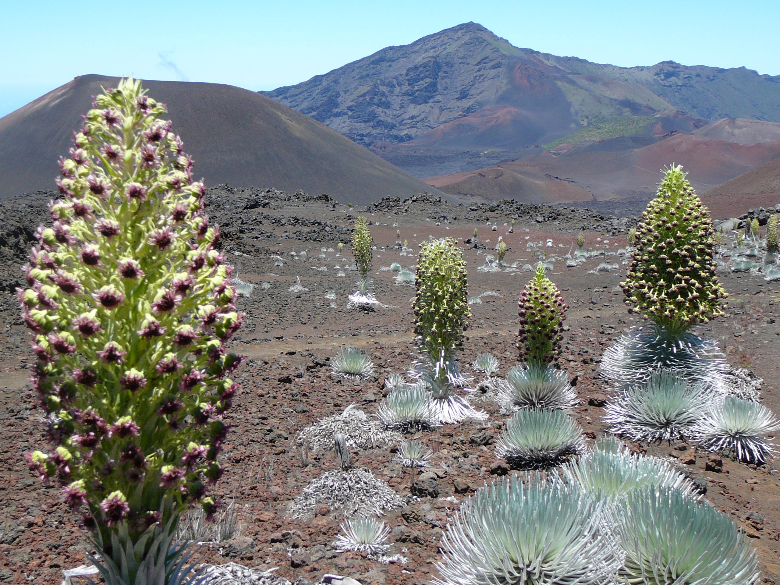
April - June: The best balance. Summit days are cool but less windy, with clearer skies. The Kipahulu side sees less frequent rain. Wildflowers, including the rare and endemic 'ahinahina (silversword), begin to bloom in the crater in late spring.
July - September: Peak dry season for the summit. This is when the sun is most intense and UV exposure is extreme. Start hikes very early. Afternoon clouds still build over the crater but rain is less likely. Kipahulu remains humid and wet, but afternoon downpours may be shorter.
October - November: Transition period. The likelihood of rain increases on both sides of the park. The summit can be clear one moment and shrouded in clouds the next. This is the least predictable time for weather, but also sees fewer visitors.

Trailhead Logistics
For summit crater hikes (Sliding Sands, Halemau'u), the parking strategy is simple: arrive early or late. The sunrise crowd clears out by 9:30 AM. If lots are full, do not park on vegetation or block roadways - rangers ticket aggressively. There are no shuttles within the park. Fill your gas tank in Kahului or Kula; there are no gas stations on the mountain. The only water available is at the visitor centers; fill all bottles there. The Haleakala Visitor Center at the summit is where you check the whiteboard for current trail conditions and weather alerts.
For the Kipahulu District (Pipiwai Trail), the challenge is the Hana Highway. The drive is part of the experience - and the bottleneck. Parking fills by late morning. Once the lot is full, do not park on the highway shoulders; it's dangerous and illegal. Consider visiting later in the afternoon when the day-tripper crowd from Hana tours has thinned. The Kipahulu Visitor Center has restrooms and trail information.
Cell service is unreliable. You'll likely lose signal entirely about 20 minutes up the summit road from Kula and won't regain it until you return. In Kipahulu, service is spotty at best. Download offline maps and trail information beforehand.
What to Carry
Forget generic lists. For Haleakala, your pack needs to address two extreme environments.
For the Summit/Crater: The sun is your primary adversary. Carry a minimum of 3-4 liters of water per person for any substantial crater hike. A wide-brimmed hat, UV-blocking sunglasses, and sunscreen (SPF 50+) are mandatory - reapply every two hours. The UV radiation at 10,000 feet is intense. Wear layers: a moisture-wicking base, an insulating mid-layer (fleece), and a windproof/waterproof shell. Temperatures can swing 30+ degrees. Footwear should be sturdy hiking boots or shoes with good tread for the loose cinder. Trekking poles are highly recommended for the descent into Sliding Sands to save your knees.
For Kipahulu: Waterproofness is key. Waterproof hiking shoes with aggressive tread are essential - trail runners will slip on the muddy roots. Pack a lightweight rain jacket even if the sky is clear. Bring 2 liters of water - while humid, there are no safe drinking water sources on trail. Bug repellent is advisable for the forested sections. A quick-dry towel is useful for the waterfall mist.
Universal: A detailed printed map. Cell service is not a planning tool here. A headlamp, even for day hikes, in case you're delayed. More snacks than you think you'll need - the exertion at altitude burns calories fast.
Practical Takeaways
- You are hiking at altitude. Even if you're fit, the thin air at 7,000-10,000 feet will affect you. Walk slower than you think you need to, drink water constantly, and listen to your body.
- The summit and the coast are a full day apart. Pick one area per day. The drive from the summit to Kipahulu is roughly 2.5 hours on winding roads.
- Parking dictates your schedule. For summit hikes, aim to finish your hike by 11 AM or start after 2 PM to avoid the worst congestion. For Pipiwai, arrive before 10 AM.
- Weather changes by the minute. The forecast at sea level is meaningless. Check the board at the visitor center for current summit conditions before you set out.
- Footwear is non-negotiable. Sandals or flip-flops are only for the parking lot. Crater cinder gets into everything, and Kipahulu trails are perpetually slick.
- There is no gas on the mountain. Fill your tank before you ascend. Running out of gas is a costly and embarrassing rescue call.
- The 'ahinahina (silversword) is fragile. Stay on the trail. These plants take decades to grow and die if their roots are disturbed.
- Carry all your trash out. There are no trash cans at trailheads. Pack it in, pack it out.
- For a complete visitor guide covering entrance fees, lodging, and general park orientation, see our complete visitor guide.
- Plan around the conditions. For insight on seasonal weather patterns to help choose your dates, review our guide on the best time to visit. If you're considering an overnight, research all camping options well in advance, as they are limited and competitive.
Recommended Gear
What experienced visitors bring to Haleakala Hiking: The Trails Actually Worth Your Time
Links may earn us a commission at no extra cost to you. We only recommend gear we believe in.
Hiking Essentials
Hydration Pack (3L)
Hands-free water for long trail days
Trekking Poles (Pair)
Save your knees on steep descents
Hiking Boots (Ankle Support)
Sturdy footwear for rocky, uneven trails
Sun & Heat Protection
Wide-Brim Sun Hat
Full coverage UPF 50+ protection at altitude
Insulated Water Bottle (32oz)
Keeps water cold in desert heat all day
Winter Gear
Microspikes / Traction Devices
Essential for icy rim trails in winter months
Packable Down Jacket
Lightweight warmth that stuffs into a pocket
Sources
- Official source: NPS — Haleakala National Park nps.gov/hale/index.htm
Photo Gallery
More to Explore

Park Guide
Acadia National Park: Carriage Roads, Cadillac Mountain & 2026 Guide
Discover carriage roads, Cadillac Mountain, and rugged Maine coast. Complete 2026 guide to Acadia National Park — trails, fees, lodging, permits, and what rangers recommend.

Hiking Guide
Grand Canyon Hiking Trails: Day Hikes, Water Sources & Rim to Rim
Compare Grand Canyon hiking trails: Bright Angel, South Kaibab, Hermit, Grandview, and rim to rim, with distances, elevation, water stops, and trailhead access for each.

Best Of
Best of Glacier Bay National Park
The best of Glacier Bay is reached by boat: ranger-led day tours up the bay to the tidewater glaciers. What's worth it, how to book, and when to go (2026).

Campsite Guide
White Sands Backcountry Camping: Closed for 2026 — What to Know
As of 2026, backcountry camping at White Sands National Park is closed for site rehabilitation. What that means, and where to camp nearby instead.

Weather Guide
Guadalupe Mountains National Park Weather: Weather
Guadalupe Mountains National Park: weather guide guide updated 2026. Practical visitor information, reservations, and seasonal tips worth bookmarking before

Best Of
Best of Cuyahoga Valley National Park: Best Things to Do
Seeing a Cleveland Orchestra concert with the woods as your backdrop is a uniquely Cuyahoga Valley experience.
Sign in to join the conversation.
Sources & Attribution
Location data courtesy of the National Park Service (U.S. Department of the Interior). NPS data is public domain.
Images: Photo by Aidan McCants on Pexels; Photo by James Wheeler on Pexels; Photo by Daniel Erlandson on Pexels; Photo by Daniel Erlandson on Pexels; Photo by James Wheeler on Pexels. Stock photos from Pexels / Unsplash license; links above point to each photo where available.
Map data © OpenStreetMap contributors.
Park operations alerts: NPS.gov · Weather and weather hazards: National Weather Service · Live conditions.
Information may change. Always verify fees, hours, and conditions directly with the official source before visiting.
Did this guide help? Share it with a friend.