Grand Canyon National Park spans 278 miles of the Colorado River and adjacent uplands, all within Arizona. The canyon reaches a mile deep at its center, exposing nearly two billion years of geologic history. The park sits on the ancestral homelands of 11 present-day Tribal Communities. The grand canyon trail of time - a self-guided interpretive walk along the South Rim - lets you trace that history step by step, with each meter representing a million years of rock.
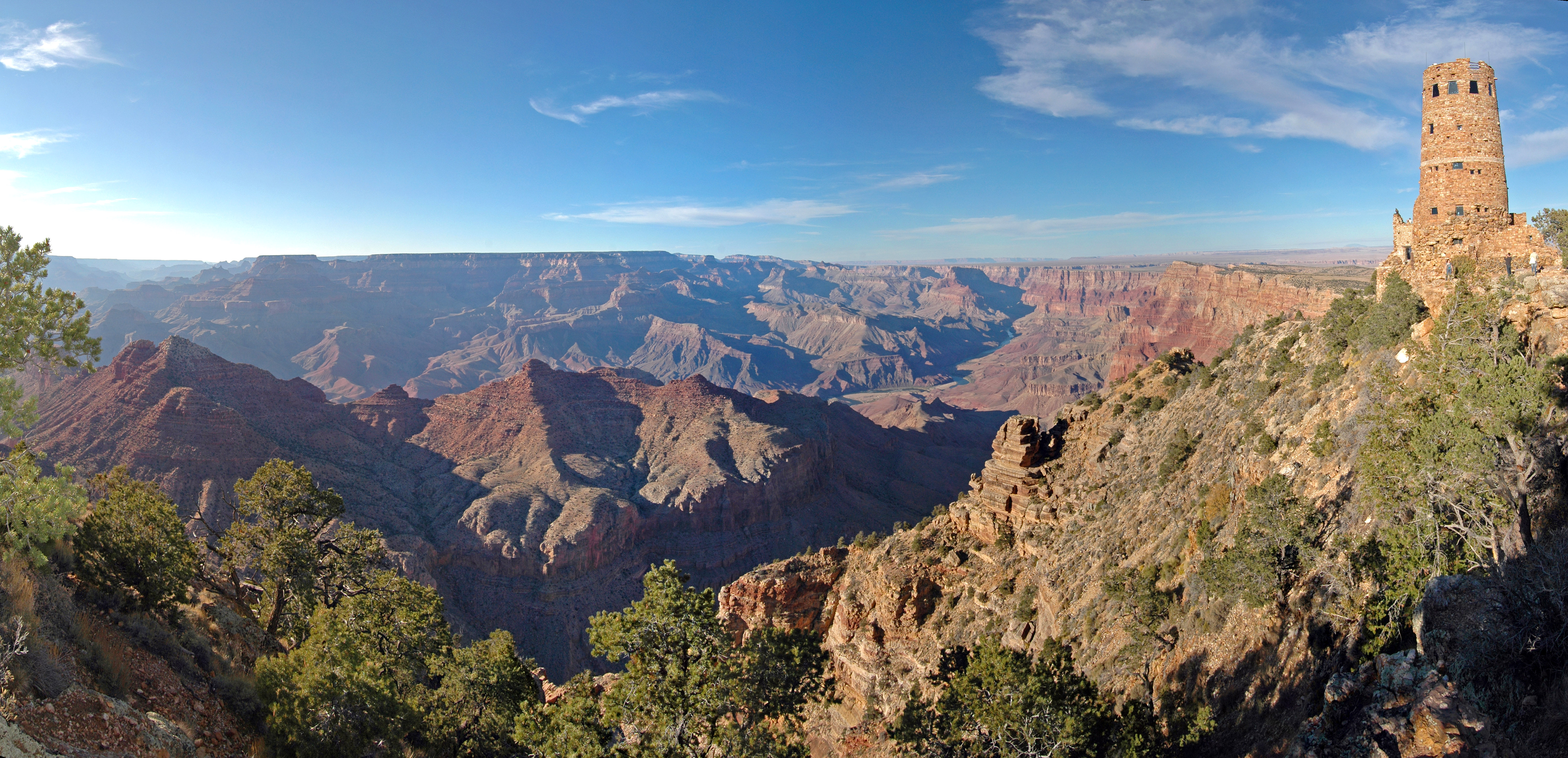
NPS/M.Quinn via NPS.gov (Public Domain)
Grand Canyon National Park: One of Earth's Greatest Wonders - 2026 Visitor Guide
8 min read
Places & Points of Interest
Discover Grand Canyon National Park's 278-mile expanse, mile-deep geology, and the Trail of Time. Learn entrance fees, rim temperatures, and seasonal access tips.
Your plans
Elevation ranges from 2,500 feet at the river to 8,400 feet on the North Rim. That 20-to-30-degree temperature difference between rim and inner canyon catches most first-time visitors off guard. Summer heat inside the canyon can exceed 110°F, while the rims stay cooler and often have afternoon thunderstorms. Winter brings snow to both rims, but the South Rim stays accessible year-round.
The park's scale is difficult to absorb from a single viewpoint. From the South Rim, the opposite wall appears close enough to touch - but it's 10 to 15 miles away. The Colorado River, visible from most overlooks, looks like a green thread. That thin line is often a quarter-mile wide in places. Rangers at the visitor center emphasize that the canyon is not a static scene; the light changes constantly, and each overlook offers a different perspective.
Quick Information
- Entrance Fee: Private vehicle $35.00, Motorcycle $30.00, Per person (hiker/bicyclist) $20.00, Nonresident surcharge $100.00 (in addition to entrance fee, unless using an America the Beautiful pass). Cash not accepted as of 2026.
- Hours: South Rim and Desert View (East Entrance) open 24 hours/day, 7 days/week. North Rim open seasonally October 1-November 14 for select areas.
- Best Time to Visit: May-June and September-October - moderate temperatures, fewer crowds than July-August, and clear skies. Check the best time to visit page for month-by-month conditions.
- Location: 20 South Entrance Road, Grand Canyon, AZ 86023. Entirely within Arizona.
- Accessibility: South Rim has paved trails and accessible shuttles. The Rim Trail from Mather Point to Grand Canyon Village is wheelchair-friendly. The Bright Angel Trail is not accessible beyond the first overlook.
- Cell Service: Spotty on the South Rim, nonexistent below the rim. Verizon and AT&T have towers near the village; T-Mobile is limited. Download maps before arrival.
- Restrooms: Flush toilets at visitor centers, lodges, and developed overlooks. Vault toilets at trailheads and remote points. No restrooms below the rim except at Phantom Ranch.
- Parking: South Entrance (Tusayan) sees lines up to two hours between 9:30 AM and 4 PM. The East Entrance at Desert View usually has shorter waits. Parking lots at Mather Point fill by 10 AM in peak season.
Getting There
South Rim (open year-round): 60 miles north of Williams, AZ via Route 64 from I-40. 80 miles northwest of Flagstaff via Route 180. Both routes are paved and well-maintained. The South Entrance Station, near Tusayan, handles the most traffic. Arrive before 8 AM or after 4 PM to avoid the wait.
East Entrance (Desert View): 32 miles east of Grand Canyon Village via SR 64. From US 89, turn west at Cameron, AZ, and drive 25 miles. This entrance usually has shorter lines and gives you your first view of the canyon at Desert View Watchtower.
North Rim (open seasonal): 30 miles south of Jacob Lake, AZ on Highway 67, then another 14 miles to the rim. Access roads close in winter. The North Rim is a 4.5-hour drive from the South Rim - not a day trip.
The nearest commercial airport is Flagstaff Pulliam Airport (FLG), about 80 miles south. Phoenix Sky Harbor (PHX) is 3.5 hours away. Shuttles and rental cars available at both.

What to Expect
The South Rim is not a single viewpoint. It stretches 13 miles from the village to Desert View, with dozens of overlooks. The Rim Trail connects many of them and is mostly flat - an easy walk with unforgettable views. The paved path runs close to the edge in places, with low retaining walls. Keep an eye out for elk grazing along the golf course and near lodges. They are wild and can charge without warning.
Below the rim, the world changes. The Bright Angel Trail descends 4,500 feet in 9.5 miles to the Colorado River. Switchbacks cut through layers of Kaibab Limestone, Toroweap Formation, Coconino Sandstone, and Hermit Shale. The trail narrows here, with steep drop-offs and no guardrails. Pack extra water for this stretch - rangers recommend one gallon per person per day below the rim.
The grand canyon trail of time on the South Rim offers a different kind of immersion. This 2.8-mile paved path between the Yavapai Geology Museum and Verkamp's Visitor Center uses bronze markers and rock samples set into the sidewalk to represent the geologic timeline. Each step across a meter of ground corresponds to a million years of Earth's history. It's a concrete way to grasp the canyon's age - something the overlooks alone don't convey.
Weather changes fast. Clear skies can turn to lightning and hail within an hour. Summer monsoons (July-September) bring sudden downpours that flood slot canyons without warning. Winters are cold and snowy on the rims - temperatures drop into the teens at night. The inner canyon stays warmer but can still get cold in December and January. Check the park's alerts for current trail closures and heat risk.
Top Attractions & Points of Interest
Mather Point
The most visited overlook, located just past the South Entrance. From this overlook you can see the canyon wall stepping down in distinct layers - the Kaibab, Toroweap, Coconino, Hermit, and Supai formations. Park rangers give short talks here throughout the day. The parking lot fills by 9 AM; the shuttle is a better option.
Desert View Watchtower
A 70-foot stone tower built in 1932 by Mary Colter, modeled after Ancestral Puebloan structures. The interior features murals and a gift shop. From the roof, you get a 360-degree view of the canyon, the Painted Desert, and on clear days, the San Francisco Peaks near Flagstaff. The adjacent Desert View Campground operates mid-April to mid-October.
Bright Angel Trail
The most popular rim-to-river trail. The first 1.5 miles to Ooh Aah Point are doable for most visitors with decent fitness. Beyond that, the trail gets steep and exposed. The National Park Service recommends turn-around times based on the season - heed them. The trail has resthouses at 1.5 and 3 miles with seasonal water. Cell service drops out at the first switchback.
South Kaibab Trail
Steeper than Bright Angel but with more open views. The trail starts at Yaki Point (accessible only by shuttle). The hike to Ooh Aah Point is shorter (0.9 miles) but the grade is relentless. The elevation gain is worth it for the uninterrupted sightlines down the canyon axis. No water on this trail.
Grand Canyon Village
Historic district with lodges, restaurants, a bank, post office, and the Grand Canyon Railway depot. The El Tovar Hotel is the historic lodge centerpiece; Bright Angel Lodge offers more modest rooms. The village is also the terminus for the grand canyon trail of time - start at Yavapai Geology Museum to follow the timeline east toward Verkamp's.

Activities
Hiking is the primary activity. The park has over 300 miles of maintained trails. Our dedicated page on hiking trails covers day hikes and backpacking permits. Most visitors underestimate the difficulty of hiking back up - the inner canyon is about altitude gain on the return. The common mistake - and almost everyone makes it - is not starting early enough. Start before sunrise in summer.
Rafting the Colorado River requires a permit (lottery in February) or a commercial trip. Trips range from 4 to 18 days. Whitewater rapids up to Class X. Non-commercial permits are extremely competitive.
Camping at Mather Campground (South Rim) and Desert View Campground (seasonal) requires reservations. Backcountry camping below the rim needs a permit from the Backcountry Information Center. See our camping options page for details.
Stargazing is exceptional. The park is an International Dark Sky Park. Night sky programs run at the visitor center. The annual Grand Canyon Star Party draws hundreds of telescope operators.
Wildlife viewing - elk, mule deer, bison (at the North Rim), California condors, and Abert's squirrels. The condor recovery program is a highlight. Look for the numbered wing tags on these birds. More on wildlife viewing (coming soon).
Fishing in the Colorado River requires an Arizona fishing license. Trout and native humpback chub are present. Catch-and-release is encouraged.
Seasonal Guide
Spring (March-May): South Rim temperatures 40-70°F. Inner canyon 60-90°F. Snowmelt on trails. Wildflowers peak in late April. Lodges fill quickly - book lodging and accommodations six months ahead.
Summer (June-August): Rim highs 80-90°F; inner canyon 100-120°F+ (yes, 120+). Thunderstorms common in July-August. South Rim crowds are heavy; North Rim opens fully. Hiking below the rim before sunrise or after sunset is advised. The park's heat risk alerts are posted daily.
Fall (September-November): Best weather. South Rim 50-80°F. Crowds drop after Labor Day. Aspens turn gold at the North Rim. North Rim services close after October 15. South Rim remains busy through October.
Winter (December-February): South Rim 20-40°F, snow frequent. North Rim closed (road unplowed). Mather Point has fewer visitors. Ice on trails can be hazardous - crampons are useful. The grand canyon trail of time is plowed and passable most days.

Practical Information
Entrance fees: $35 private vehicle (7 days), $30 motorcycle, $20 per person (bicyclist/hiker). Non-US residents 16+ pay an additional $100 fee unless holding an America the Beautiful pass. The pass can be purchased at the entrance station (credit card only - no cash). Long line waits are typical 9:30 AM-4 PM.
Lodging: Inside the park - El Tovar, Bright Angel Lodge, Maswik Lodge, Thunderbird Lodge (all South Rim). Phantom Ranch at the bottom of the canyon (requires reservation lottery for dorm beds). Outside - Tusayan (1 mile south) has hotels and restaurants. Book a year in advance for summer.
Food: Grand Canyon Village has a grocery store, deli, and restaurants. Desert View has a snack bar during summer. No food below the rim except at Phantom Ranch (advance reservations required).
Shuttle system: Free, runs on the South Rim from early morning to sunset. Three routes: Village (blue), Kaibab Rim (orange), Hermit Road (red - seasonal). The red route serves the western overlooks with no private vehicle access from March to November.
Rentals: No bike rentals in the park, but there are shops in Tusayan. Day packs, trekking poles, and stoves available at the general store.
Safety & Preparation
The biggest danger is heat. The inner canyon is 20-30 degrees warmer than the rim. Rangers respond to dozens of heat exhaustion cases each summer. Hiking below the rim between 10 AM and 4 PM in summer is not recommended for most people. Rangers will tell you that
For more information, see our complete National Park Guide.
Sources
- Official source: NPS — Grand Canyon National Park nps.gov/grca/index.htm
Photo Gallery
More to Explore

Park Guide
Acadia National Park: Carriage Roads, Cadillac Mountain & 2026 Guide
Discover carriage roads, Cadillac Mountain, and rugged Maine coast. Complete 2026 guide to Acadia National Park — trails, fees, lodging, permits, and what rangers recommend.

Hiking Guide
Grand Canyon Hiking Trails: Day Hikes, Water Sources & Rim to Rim
Compare Grand Canyon hiking trails: Bright Angel, South Kaibab, Hermit, Grandview, and rim to rim, with distances, elevation, water stops, and trailhead access for each.

Best Of
Best of Glacier Bay National Park
The best of Glacier Bay is reached by boat: ranger-led day tours up the bay to the tidewater glaciers. What's worth it, how to book, and when to go (2026).

Campsite Guide
White Sands Backcountry Camping: Closed for 2026 — What to Know
As of 2026, backcountry camping at White Sands National Park is closed for site rehabilitation. What that means, and where to camp nearby instead.

Weather Guide
Guadalupe Mountains National Park Weather: Weather
Guadalupe Mountains National Park: weather guide guide updated 2026. Practical visitor information, reservations, and seasonal tips worth bookmarking before

Best Of
Best of Cuyahoga Valley National Park: Best Things to Do
Seeing a Cleveland Orchestra concert with the woods as your backdrop is a uniquely Cuyahoga Valley experience.
Sign in to join the conversation.
Sources & Attribution
Location data courtesy of the National Park Service (U.S. Department of the Interior). NPS data is public domain. Official NPS page.
Images: NPS/M.Quinn; NPS/M.Quinn; NPS/M.Quinn; NPS.
Map data © OpenStreetMap contributors.
Park operations alerts: NPS.gov · Weather and weather hazards: National Weather Service · Live conditions.
Information may change. Always verify fees, hours, and conditions directly with the official source before visiting.
Did this guide help? Share it with a friend.