For more, see best time to visit.
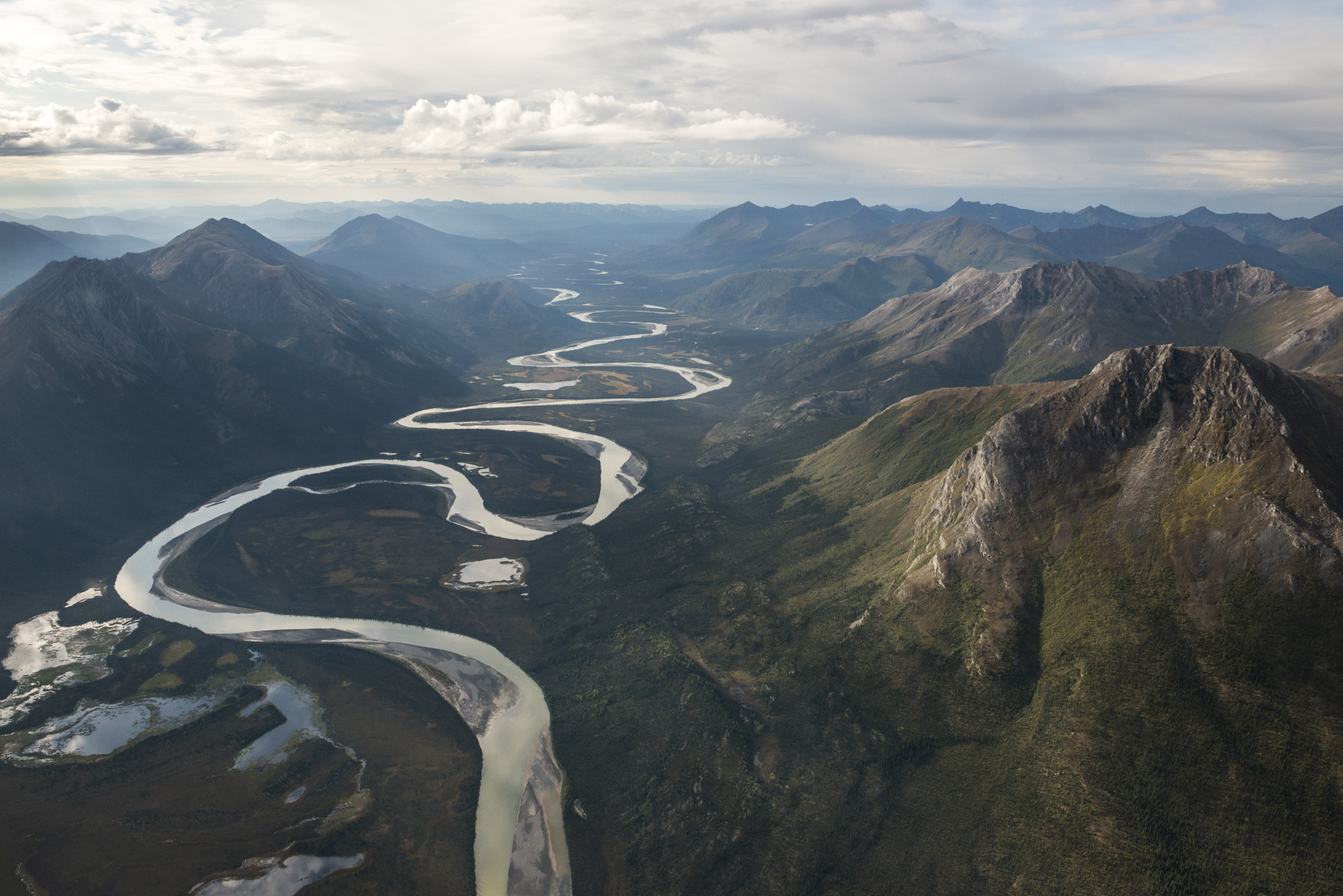
NPS via NPS.gov (Public Domain)
Gates of the Arctic National Park Hiking: Hiking
12 min read
Hiking Guide
No trails, no roads - every step in Gates of the Arctic is off-trail route-finding with map and compass across tundra and river crossings (2026).
This article contains affiliate links — we may earn a small commission at no extra cost to you.
What Hiking Here Actually Means
Before we talk about routes, you need to understand what "hiking" means at this particular park. There are no trails. None. The research data is explicit: this landscape contains no roads or trails. Every step you take here is off-trail, route-finding across tundra, gravel bars, and steep mountain slopes. This is not a place for marked paths, trail signs, or maintained switchbacks.
gates of the arctic national park hiking is the most backcountry-intensive hiking experience in the entire National Park System. First-time visitors consistently underestimate how much navigation and route-finding skill this demands. You will be reading terrain, not following blazes. You will cross rivers - multiple times, on foot, with no bridge. You will carry everything on your back for the entire duration of your trip.
Rangers at the Fairbanks visitor center emphasize one thing above all else: if you cannot confidently navigate using a map and compass in whiteout conditions, this is not the park for you yet. GPS units fail in these latitudes. Cell service drops out at the city limits of Fairbanks. The people who struggle here are not the ones who underestimated the physical difficulty - they are the ones who underestimated the navigation requirement.
The reward for that effort is a landscape virtually unchanged by human hands. Caribou follow migration routes that predate recorded history. Wild rivers run through glacier-carved valleys. The summer sun never fully sets, and the winter sky burns with aurora. You earn every view here.
For context on the full scope of what this park offers, check the complete visitor guide. For specifics on when to come, read the best time to visit page. What follows is strictly about the hiking itself.
Hiking from the Dalton Highway Corridor
This is the most common access point for independent hikers. The Dalton Highway runs along the eastern boundary of the park, and several pull-offs provide starting points for trips into the Brooks Range. This is not a scenic drive - the Dalton is a working industrial highway serving the oil fields, with heavy truck traffic and limited services.
Walker Lake Approach
Distance: 20-30 miles round trip depending on your specific route
Elevation Gain: 1,500-2,500 feet, with multiple drainage crossings
Trailhead & Parking: Drive the Dalton Highway to the pull-off near the Walker Lake access point. Parking is on gravel shoulders. There are no designated lots, no facilities, and no services. The pull-off fills with about 8-10 vehicles on summer weekends. Arrive early or you will be hiking an extra mile just to reach the start point. The nearest gas and supplies are in Coldfoot, 60 miles south.
The Trail: There is no trail. You follow the drainage north, picking your way along gravel bars and through willow thickets. The terrain transitions from boreal forest near the highway to open tundra as you gain elevation. You will cross the same river multiple times - water levels change daily with temperature and rainfall. By late July, the water is typically 18-30 inches deep and moving fast. Trekking poles are not optional here; they are stability equipment for river crossings.
The Moment: About 8 miles in, the valley opens and you get your first unobstructed view of the Brooks Range proper. The scale is disorienting - peaks that look two miles away take four hours to reach.
What Most Underestimate: River crossings. People plan for the hiking and forget that the route requires wading through snowmelt-fed rivers multiple times per day. The water temperature sits in the low 40s even in August. Your feet will go numb within 30 seconds. Wearing water shoes for crossings and switching back to dry footwear is the only sane approach.
Best Time: Late June through mid-August. Earlier and the rivers are dangerously high from snowmelt. Later and the days shorten noticeably.
The Gates of the Arctic Traverse (via the Dalton Highway)
Distance: 50-100 miles depending on your chosen route
Elevation Gain: 5,000-8,000 feet cumulative over multiple drainages
Trailhead & Parking: Same Dalton Highway pull-offs. The traverse typically begins at one pull-off and ends at another, requiring a vehicle shuttle or prearranged pickup. The parking situation here is minimal - you leave a vehicle on the shoulder for a week or more, which carries obvious risks. Most people arrange a drop-off with an air taxi from Coldfoot instead.
The Trail: This is a true wilderness traverse. You navigate from drainage to drainage, over passes that range from 3,500 to 5,500 feet. The surface changes from tussock tundra (which is like hiking on bowling balls covered in moss) to scree slopes to gravel bars. The tussocks will test your ankles in ways no other terrain does. Experienced visitors know to step on the tops of the tussocks, not between them. The common mistake - and almost everyone makes it - is trying to go around the tussocks, which only doubles the distance.
The Moment: Crossing your first unnamed pass at 4,000 feet, looking down into a valley that has no trail, no structures, and no evidence of human presence. Just the river, the caribou trails, and the wind.
What Most Underestimate: The mental toll of routefinding for 7-10 consecutive days. Picking a line across tundra, second-guessing yourself, re-routing around an impassable drainage, climbing a ridge to scout the next valley - this is constant decision-making that exhausts you in a different way than the physical effort does.
Best Time: July through early August for the longest days and most stable weather.

Hiking from Anaktuvuk Pass
Anaktuvuk Pass is a small Nunamiut Iñupiat village located within the park boundaries. You can fly in from Fairbanks via a scheduled airline. The village has limited services - a small store, airstrip, and not much else. This is the only community within the park, and visitors are guests on traditional lands.
John River Corridor
Distance: Highly variable, typically 30-60 miles point-to-point
Elevation Gain: 2,000-4,000 feet depending on how far up the side drainages you go
Trailhead & Parking: The trailhead is essentially the village. You walk south out of Anaktuvuk Pass and follow the John River drainage. There is no parking because there are no vehicles. Air taxi drops you at the village airstrip, and you start hiking from there.
The Trail: The John River corridor provides more defined travel routes than the open tundra of the Dalton approaches. River bars offer firm walking surfaces, and the valley walls funnel wildlife and travel routes into predictable patterns. However, the river itself is the primary travel corridor, and it braids constantly. You will find yourself crossing channels every few miles. The upside is that water sources are never an issue. The downside is that you cannot avoid getting wet.
The Moment: The first time you see caribou on the tundra above the valley. They move at a steady trot that eats miles without apparent effort. If you sit still long enough, they will pass within 200 yards, completely unbothered by your presence.
What Most Underestimate: The cultural dimension of hiking here. You are traveling through lands that people have occupied for over ten thousand years. Archaeological sites are everywhere, though you might not recognize them without training. The park service asks that you leave everything in place, take nothing, and camp at least a quarter mile from any visible site.
Best Time: June through September, though September brings fall colors and the first real cold.
Air Taxi Drop Hiking
Most visitors to Gates of the Arctic access the interior of the park by air taxi. Small bush planes depart from Bettles, Coldfoot, and Anaktuvuk Pass, dropping hikers at predetermined coordinates on gravel bars or tundra strips. This is not cheap - expect to pay $500-$1,200 per person for a drop and pickup depending on distance.
Arrigetch Peaks Area (via air taxi from Bettles)
Distance: 15-30 miles for a loop from a drop zone
Elevation Gain: 3,000-5,000 feet
Drop Zone: Air taxis from Bettles fly to the Arrigetch Creek drainage. The plane lands on a gravel bar. The pilot agrees on a pickup date and coordinates, then flies away. You are now alone with your gear in a landscape that sees maybe 200 human visitors per year.
The Trail: The Arrigetch Peaks are the most celebrated hiking destination in the park. The granite spires rise directly from the tundra, and the walking routes through the valley are among the most straightforward off-trail terrain in the Brooks Range. Granite slabs provide good footing. The valleys drain well. The views are sustained and constant. Most 7-day trips spend 3-4 days in the main valley and 2-3 days exploring side drainages.
The Moment: Standing below the Arrigetch spires at midnight in July, with the sun skimming the horizon and the granite faces glowing orange. It does not get dark. You lose all sense of time.
What Most Underestimate: The cost and logistics of the air taxi. You are booking weeks in advance. Weather can delay your pickup by days - you need to carry extra food for that possibility. The pilot will not fly in fog. You might wait at the pickup point for three days before the plane can get in. Most people plan for 7 days on the ground and carry 10 days of food.
Best Time: July 1 through August 15 for the best balance of weather, river levels, and daylight.
Noatak River Headwaters
Distance: 40-80 miles for a typical trip
Elevation Gain: Minimal along the river corridor, significant if you climb into side valleys
Drop Zone: Air taxi drops you at the headwaters of the Noatak River. From there, you hike downstream, usually with a combination of walking and packrafting. The river runs through the Noatak National Preserve as well as the park, and the entire corridor is a designated Wild and Scenic River.
The Trail: The Noatak corridor is flatter than the Arrigetch or the John River. Walking is on gravel bars and tundra benches above the river. The scale is enormous - the valley floor is 2-4 miles wide in places, with gentle gradients that let you cover ground efficiently. This is not technical terrain. It is endurance terrain. You can walk 12-15 miles per day on the gravel bars if you pace yourself.
The Moment: Rounding a bend in the river and seeing the entire expanse of the valley open ahead - tundra stretching to the horizon, the river braiding silver across the floor, not a single human structure visible in any direction.
What Most Underestimate: The bears. Grizzly bears in Gates of the Arctic see few humans and have no fear of them. They are curious and unpredictable. The park service requires bear-resistant food canisters. Carry bear spray and know how to use it. Do not cook within 100 yards of your tent. Do not store food anywhere near your sleeping area. These are not suggestions.
Best Time: Late June through August.

Seasonal Trail Conditions
June
Snow lingers above 2,500 feet. River crossings are dangerous - high, fast, and cold. The bugs have not peaked yet, which is the only good news. Most experienced hikers wait until late June.
July
Peak season. Longest days (22+ hours of daylight at 67°N). Rivers drop to their lowest levels by late July. Tundra is firm. Bugs are brutal - you will need a head net and permethrin-treated clothing. This is the month for serious trips.
August
Rivers rise again with increased rainfall. Days shorten noticeably by mid-month. The mosquito pressure drops after the first frost, which usually hits the higher elevations in mid-August. Fall colors peak in late August. Good month for hiking. Fewer people, lower bugs, cooler temperatures.
September
Hunting season. The park allows hunting under state regulations. Wear bright colors if you are hiking during this month. Snow begins falling at higher elevations by late September. Air taxi operations become less reliable due to weather. Not recommended for first-time visitors.
Trailhead Logistics
Dalton Highway Pull-offs
The parking situation here is nonexistent in any formal sense. You park on gravel shoulders. Theft is rare but not impossible. Leave nothing visible in your vehicle. The Coldfoot truck stop has limited parking and is the most secure option for long-term vehicle storage. Call ahead to ask about availability.
Air Taxi Logistics
Three air taxi services operate regularly in the park from Bettles and Coldfoot. You need to call to arrange drop and pickup times. The park website maintains a current list. Gates of the Arctic guided trips are available through licensed outfitters if you want a supported experience rather than independent travel.
Ranger Station
The Bettles Ranger Station is the primary contact point. Arctic Interagency Visitor Center in Coldfoot provides information as well. Neither is on the trail - these are planning resources accessed before your trip starts. Rangers will review your route, check your gear, and issue backcountry permits.
Water Sources
You will never be far from running water in this park. Treat everything - giardia is present in all surface water. Filtration works but filters freeze at night. Chemical treatment is more reliable in shoulder seasons.
Bear Canisters
Required by park regulation. Hard-sided canisters only. Ursacks are not acceptable. You can rent canisters at the Bettles Ranger Station. Plan for one canister per person per 5-7 days of food.

What to Carry
This is not a gear list for casual day hiking. Gates of the Arctic demands expedition-level preparation.
Footwear: Non-waterproof trail runners for hiking. Separate river-crossing shoes. Your feet will be wet daily - waterproof boots become waterlogged and take days to dry. Trail runners dry in hours. This is counterintuitive to most first-time visitors, but rangers will tell you it is the correct approach.
Navigation: Paper map (topographic), compass, and the skill to use both. GPS as backup only. Download maps before you leave Fairbanks - there is no cell signal anywhere in the park.
Shelter: Four-season tent. The wind in the Brooks Range is constant and strong. A three-season tent will fail in a sustained storm. Your tent stakes should be heavy-duty - the standard aluminum ones bend in the gravel.
Sleep System: Rated to 20°F minimum, 0°F if hiking in June or September. The ground is cold even in summer.
Pack raft (optional): Many experienced hikers bring pack rafts to cross rivers and lakes. This opens up routes that are otherwise impassable. If you plan to hike from Coldfoot, a pack raft transforms what is possible.
Insect Protection: Head net. Permethrin-treated clothing. Picaridin lotion for any exposed skin. The mosquitoes in July are dense enough that you will inhale them without a head net.
Food: Minimum 10 days of food for any 7-day trip. Factor in weather delays for air taxi pickups. Freeze-dried meals plus calorie-dense snacks. You will burn 4,000-5,000 calories per day hiking with a full pack.
Practical Takeaways
- The single biggest mistake hikers make at Gates of the Arctic is underestimating navigation requirements. Practice map and compass navigation before you arrive. In fog, you can lose visibility to 50 feet for two days straight.
- River crossings are the most dangerous part of any trip. Never cross alone. Unbuckle your hip belt so you can shed your pack if you fall. Use trekking poles for stability. Cross early in the morning when water levels are lowest.
- Weather changes fast. The research data describes it as "arctic and sub-arctic" with rapid shifts. A clear morning can become a freezing rainstorm by noon. You carry the gear for all conditions every day you are out.
- Leave your itinerary with someone reliable. The park service requests a trip plan. Give a copy to the ranger station and a copy to someone outside Alaska. If you miss your pickup, search and rescue is not quick in this terrain.
- gates of the arctic national park hiking is not measured in miles per hour. Plan for 1-1.5 miles per hour on tussock tundra. Gravel bars allow 2-2.5 miles per hour. Do not plan for more than 8 miles per day on any multi-day trip.
- The bugs are worse than you imagine. Multiple people cut trips short every year because they could not tolerate the mosquito density. Bring a head net. Use it. Do not feel embarrassed.
- For logistics on overnight stays, read about the camping options page. The backcountry camping here requires specific gear and permit procedures.
- Pack extra food. Always. Whether weather delays your pickup or you simply burn more calories than expected, an extra 2-3 days of food is your insurance policy.
- The best resource for current trail conditions is the Bettles Ranger Station at 907-459-3730. Call them the week before your trip. They know what the rivers are doing and where the bears are active.
- how to get to gates of the arctic starts in Fairbanks. Fly to Bettles, Coldfoot, or Anaktuvuk Pass on a scheduled airline. From there, you walk. Everything you need for the duration of your trip goes on your back. Nothing else.
For gates of the arctic traverse map resources, the USGS 1:63,360 scale topographic maps covering the Brooks Range are the standard. You will need multiple sheets for any multi-day route. The Bettles Ranger Station sells them, or you can download digital copies before you leave home. The park website provides a map index showing which quadrangles cover which areas.
This is not a casual hiking destination. It is the most demanding hiking experience in the National Park System. The people who succeed here are the ones who prepared specifically for this terrain, this weather, and this level of isolation. If you do that preparation, Gates of the Arctic will give you something no other park can
For more information, see our complete National Park & Preserve Guide.
Related: gates of the arctic maps guide
Related: how to get to gates of the arctic guide
Recommended Gear
What experienced visitors bring to Gates of the Arctic National Park Hiking: Hiking
Links may earn us a commission at no extra cost to you. We only recommend gear we believe in.
Hiking Essentials
Hydration Pack (3L)
Hands-free water for long trail days
Trekking Poles (Pair)
Save your knees on steep descents
Hiking Boots (Ankle Support)
Sturdy footwear for rocky, uneven trails
Sun & Heat Protection
Wide-Brim Sun Hat
Full coverage UPF 50+ protection at altitude
Insulated Water Bottle (32oz)
Keeps water cold in desert heat all day
Winter Gear
Microspikes / Traction Devices
Essential for icy rim trails in winter months
Packable Down Jacket
Lightweight warmth that stuffs into a pocket
Sources
- Official source: NPS — Gates of the Arctic National Park nps.gov/gaar/index.htm
Photo Gallery
More to Explore

Park Guide
Acadia National Park: Carriage Roads, Cadillac Mountain & 2026 Guide
Discover carriage roads, Cadillac Mountain, and rugged Maine coast. Complete 2026 guide to Acadia National Park — trails, fees, lodging, permits, and what rangers recommend.

Hiking Guide
Grand Canyon Hiking Trails: Day Hikes, Water Sources & Rim to Rim
Compare Grand Canyon hiking trails: Bright Angel, South Kaibab, Hermit, Grandview, and rim to rim, with distances, elevation, water stops, and trailhead access for each.

Best Of
Best of Glacier Bay National Park
The best of Glacier Bay is reached by boat: ranger-led day tours up the bay to the tidewater glaciers. What's worth it, how to book, and when to go (2026).

Campsite Guide
White Sands Backcountry Camping: Closed for 2026 — What to Know
As of 2026, backcountry camping at White Sands National Park is closed for site rehabilitation. What that means, and where to camp nearby instead.

Weather Guide
Guadalupe Mountains National Park Weather: Weather
Guadalupe Mountains National Park: weather guide guide updated 2026. Practical visitor information, reservations, and seasonal tips worth bookmarking before

Best Of
Best of Cuyahoga Valley National Park: Best Things to Do
Seeing a Cleveland Orchestra concert with the woods as your backdrop is a uniquely Cuyahoga Valley experience.
Sign in to join the conversation.
Sources & Attribution
Location data courtesy of the National Park Service (U.S. Department of the Interior). NPS data is public domain. Official NPS page.
Images: NPS; NPS; NPS; NPS; NPS.
Map data © OpenStreetMap contributors.
Park operations alerts: NPS.gov · Weather and weather hazards: National Weather Service · Live conditions.
Information may change. Always verify fees, hours, and conditions directly with the official source before visiting.
Did this guide help? Share it with a friend.