What defines a good June hike in Yellowstone versus those that just look good on a map? Snow coverage and road access - two factors that determine whether you actually reach the trailhead or stare at a closed gate.
NPS via NPS.gov (Public Domain)
Yellowstone National Park Hiking: Best Yellowstone Hikes in June
13 min read
Hiking Guide
Snow and road access decide which Yellowstone trails work in June; Dunraven Pass stays closed as of mid-2026, so use Chittenden Road to reach Mount Washburn.
This article contains affiliate links — we may earn a small commission at no extra cost to you.
June is a transition month across the park's 3,500 square miles. Lower-elevation trails in the northern range are usually dry by late May. Higher routes - anything above 8,000 feet - can hold snow well into July. The park's roads open on staggered schedules, with Dunraven Pass typically the last to clear. As of mid-2026, that road remains closed, which cuts off access to the Mount Washburn trails from the Dunraven side, but the Chittenden Road approach is your workaround.
This guide covers the trails that actually work in June - ones where the snow has melted, the parking lots are reachable, and the payoff justifies the planning. For park logistics beyond hiking, including entrance fees and seasonal road status, the complete visitor guide covers that ground.
What Hiking Here Actually Means
Yellowstone hiking has a specific character that catches first-time visitors off guard. You are walking through an active volcanic landscape. That means boardwalks over thin-crusted thermal areas, trails that cross open meadows where bison have the right of way, and routes that climb through forest that burned in 1988 - those ghostly white snags still standing 38 years later.
Elevation ranges from 5,300 feet at the north entrance to 11,358 feet at Mount Washburn's summit. June hikers contend with afternoon thunderstorms that drop temperatures by 20 degrees in minutes, snow patches on north-facing slopes at higher elevations, and trailhead parking that fills by 8:30 AM at the busiest lots. The park's five entrances are spaced hours apart by driving, so you pick your zone and commit to it for the day.
Most visitors underestimate how much distance they need to cover between trailheads. From Old Faithful to the Canyon area is a 90-minute drive. From Canyon to Tower-Roosevelt is another 45 minutes when Dunraven Pass is open - longer when it isn't. You plan your hiking day around one zone, not multiple.
Fairy Falls + Grand Prismatic Overlook Trail: The One You Cannot Skip
Distance: 3.6 miles round trip total (1.6 miles to Fairy Falls, plus 0.6 miles each direction for the overlook spur)
Elevation Gain: 200 feet total - gentle, with a 105-foot climb for the overlook segment
Trailhead & Parking: Fairy Falls Trailhead, located along the Grand Loop Road between the Old Faithful and West Thumb areas, about 3.5 miles south of the Madison Junction. The parking lot holds maybe 40 vehicles. It fills by 8 AM in June. Overflow parking is nonexistent - you either arrive early or you wait for someone to leave. Rangers will tell you to arrive before 7:30 AM if you want a spot. Cell service drops out at the trailhead and doesn't return until you're back on the main road.
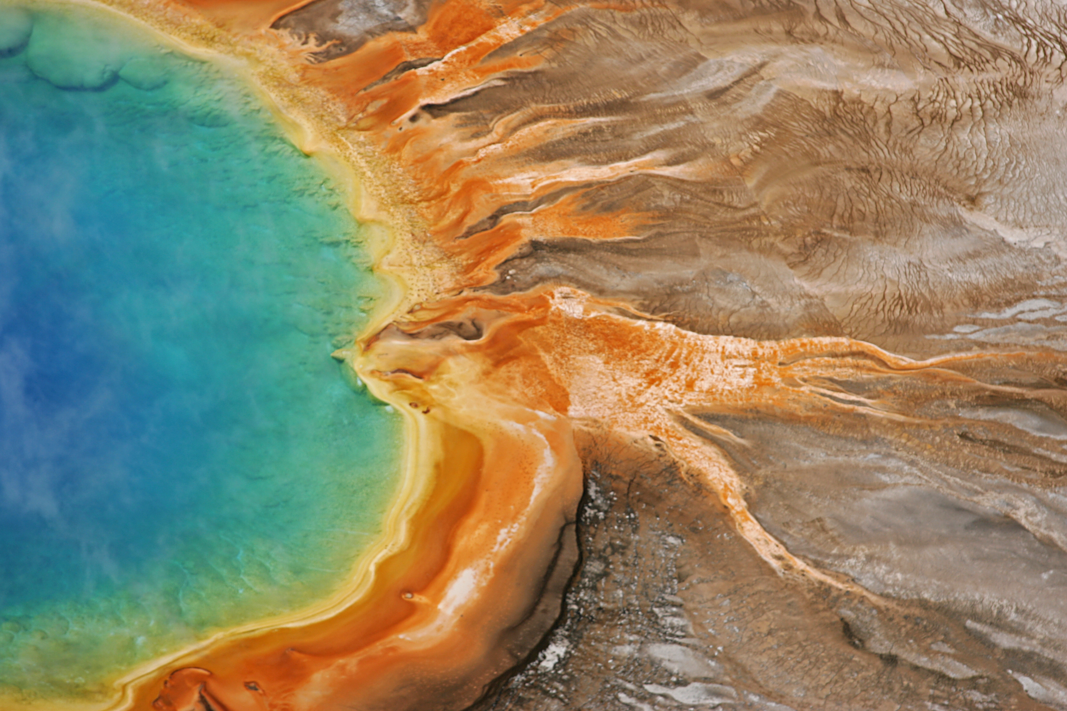
The Trail: The path to Fairy Falls follows an old service road through a young lodgepole pine forest - most of it regrown after the 1988 fires. The surface is packed gravel and dirt, flat enough that you could maintain a steady walking pace the whole way. About 0.6 miles in, a signed junction branches left up a gradual slope to the Grand Prismatic Overlook. Take this detour first. The overlook trail climbs 105 feet over 0.6 miles - switchbacks cut into the hillside, nothing technical but your calves will register the grade after the flat approach. From the top, you look straight down into Grand Prismatic Spring, the largest hot spring in the United States. The colors shift with the season and the light: deep blue center, bright orange bacterial mats at the edges, steam rising in the cold morning air.
Back on the main trail, continue another mile to Fairy Falls itself. The waterfall drops 200 feet over a volcanic cliff face. In June, snowmelt swells the flow. You can feel the spray from 50 yards away.
The Moment: Standing at the Grand Prismatic Overlook at 8 AM on a clear morning, looking down at that impossible blue-orange pool with no crowds blocking your view. The main boardwalk below is already shoulder-to-shoulder. You have this angle entirely to yourself.
What Most Underestimate: The overlook trail gets direct sun exposure most of the morning. You will want sun protection even if the temperature is only 55°F. The UV at 7,500 feet is stronger than you expect.
Best Time: 7 AM to 9 AM for the overlook. Earlier is better. The Fairy Falls trail stays pleasant until early afternoon if clouds roll in.

Canyon Area Trails
Brink of the Lower Falls Trail
Distance: 0.7 miles round trip. One way down, one way back up.
Elevation Gain: 600 feet on the return climb. You descend into the canyon, so coming back is the workout.
Trailhead & Parking: South Rim Drive, Grand Canyon of the Yellowstone area. Parking lot at the trailhead holds about 60 vehicles. Fills by 9 AM in June. Overflow available at the main Canyon Village lots with a shuttle or a half-mile walk.
The Trail: The trail starts paved and immediately drops via switchboards built into the canyon wall. Between 5,000 and 60,000 gallons of water per second go over the Lower Falls depending on snowmelt timing - June is peak flow. The railings are solid, the steps are maintained, and there are rest platforms at the switchbacks. You will feel this climb on the way back - 600 feet of gain in a half-mile is steep enough that hikers in average shape take 15-20 minutes to make the return.
The Moment: At the bottom platform, the spray reaches you. The sound is a constant roar. Looking straight up at the 308-foot waterfall from close range gives you a sense of scale that the distant overlooks cannot touch.
What Most Underestimate: The stairs are wet in June from spray and condensation. Footing on the metal steps can be slick. Trail runners without tread are a bad choice here.
Best Time: 10 AM to 2 PM when sunlight hits the falls directly and produces a rainbow in the mist at the base.
Cascade Lake Trail
Distance: 7 miles round trip
Elevation Gain: 350 feet - gentle, rolling terrain
Trailhead & Parking: Cascade Lake Trailhead, located on the Norris-Canyon Road about 2 miles west of Canyon Village. Small parking area, roughly 20 vehicles. Less crowded than the main Canyon lots because most visitors head straight for the rim trails.
The Trail: The trail passes through open meadows and scattered forest. In June, wildflowers are at their peak - lupine and Indian paintbrush crowd the trail edges. The lake itself sits in a small basin at about 8,000 feet. Snow can linger on the north side of the trail into early June. Wildlife is common - sandhill cranes, elk, and if you're lucky, a moose in the marshy edges of the lake.
The Moment: The meadow approach to the lake around mid-morning, when the sun clears the ridge and lights up the flowers.
What Most Underestimate: The trail can be soft and boggy in June. Waterproof boots matter more here than on any other trail on this list.
Best Time: Late morning to early afternoon. The meadow is exposed - heat and sun are factors by 2 PM.
Wildlife-Oriented Hikes
Pelican Valley Trail
Distance: 6.4 miles round trip to the lake and back
Elevation Gain: 200 feet - essentially flat
Trailhead & Parking: Pelican Valley Trailhead, located on the Fishing Bridge Junction-Lake Village Road. Moderate-sized lot. Arrive by 7:30 AM in June.
The Trail: You are entering some of the best grizzly habitat in the lower 48 states. The trail crosses open meadows, follows the edge of Pelican Creek, and ends at Pelican Lake. The trail surface is packed dirt and grass with occasional muddy sections. No boardwalks, no railings - you are in the middle of it.
Rangers require a minimum group size of 3 in this area. Carry bear spray in an accessible holster, not buried in your pack. Make noise at blind corners. The trail is open only after 9 AM to reduce bear encounters during feeding hours, and you must be done hiking by 7 PM.
The Moment: Seeing bison grazing in the meadow with Pelican Lake as the backdrop. The scale of the valley is enormous - you feel small in a way that other trails don't deliver.
What Most Underestimate: This is not a casual stroll despite being flat. The grizzly risk is real. Take the bear safety briefing at the ranger station seriously.
Best Time: 9 AM to 11 AM. Early enough to avoid afternoon heat, late enough for the 9 AM opening.
Trout Lake Trail
Distance: 1.2 miles round trip
Elevation Gain: 200 feet in a short, steep climb
Trailhead & Parking: Trout Lake Trailhead, located on the Northeast Entrance Road about 2 miles east of Tower-Roosevelt. Small lot that fills quickly. Lane parking along the road is allowed but limited.
The Trail: Short hill climb through Douglas-fir forest to a small lake ringed by lily pads. In June, the cutthroat trout spawn at the lake's inlet stream. River otters are frequently seen fishing here. The trail is steep for its length - you earn the view in about 15 minutes of climbing.
The Moment: Watching river otters work the inlet stream while the lake reflects the surrounding hills.
What Most Underestimate: The parking situation is tight. This is a quick hike that people do as a stop between longer drives, so turnover is high but so is competition for spaces.
Best Time: Late afternoon when the light softens and otters are most active.
Specimen Ridge Day Hike Trail
Distance: 5 miles round trip (or longer if you extend along the ridge)
Elevation Gain: 800 feet
Trailhead & Parking: Specimen Ridge pullout on the Lamar Valley Road, about 4 miles east of Tower-Roosevelt. Shoulder parking only - no formal lot.
The Trail: Follow an abandoned service road for about 100 yards, then veer right onto a path that climbs toward the ridge. The elevation gain is steady but manageable. From the top, the view across Slough Creek Valley and the Absaroka Range is wide-open. Petrified wood is scattered along the ridge - pieces of ancient trees turned to stone by volcanic ash millions of years ago. The trail is less maintained than the park's major routes; expect uneven ground and loose rock in sections.
The Moment: The first glimpse of the Absaroka Range from the ridge top - a 50-mile view of peaks still holding snow in June.
What Most Underestimate: The trail requires route-finding ability. Cairns mark the way in some sections, but they are spaced widely. Download a GPS track before you go. Cell service drops out at the pullout and does not return.
Best Time: Early morning for wildlife in Lamar Valley before climbing the ridge.

Short & Unique
Mud Volcano Trail
Distance: 0.8 miles loop
Elevation Gain: 50 feet
Trailhead & Parking: Mud Volcano parking area on the Grand Loop Road, about 6 miles south of Canyon Village. Large lot for a thermal feature stop. Moderate crowds June through August.
The Trail: Boardwalk loop through one of Yellowstone's most active hydrothermal areas. The ground here is thin - you smell sulfur before you see the features. Dragon's Mouth Spring pulses steam across an opening that looks like a cave. Mud pots bubble and pop. The trail is paved boardwalk the entire way, suitable for any fitness level.
The Moment: Watching a mud pot explode at close range - a thick pop that sounds like a pot of boiling oatmeal left unattended.
What Most Underestimate: The smell is strong. If you are sensitive to sulfur, this trail is harder than its length suggests.
Best Time: Any time of day. Morning has lighter crowds. The features look best in overcast light when steam contrasts against gray sky.
Forces of the Northern Range Self-Guided Trail
Distance: 0.5 miles
Elevation Gain: None - entirely flat boardwalk
Trailhead & Parking: Located on the Mammoth-Tower Road. Small lot.
The Trail: Eleven interpretive stops on a half-mile boardwalk explaining how geology shapes the northern range. The trail overlooks the Yellowstone River Valley. In June, bison and pronghorn are visible from the boardwalk. The exhibits are well-written and worth reading - they cover fire ecology, geothermal influence on grasslands, and wildlife movement patterns.
The Moment: Reading the exhibit about the 1988 fires while looking at a landscape that has recovered completely.
What Most Underestimate: This is not a strenuous hike. It is an educational walk. Plan it as a warm-up or a rest-day activity.
Best Time: Late afternoon when the light slants across the valley and wildlife is most visible.
Seasonal Trail Conditions: June Specifics
June hiking at Yellowstone splits into two distinct periods, and the difference matters more than most visitors realize.
Early June (June 1-15): Snow lingers above 8,000 feet on north-facing slopes. Trails like Mount Washburn via Chittenden Road may still have snow patches at the summit. Pelican Valley opens at 9 AM daily after bear management evaluation. The south entrance opens to wheeled vehicles around the second Friday of May - by early June, all main roads except Dunraven Pass are typically open. Creek crossings run high from snowmelt. The Gardner River bridge on Rescue Creek Trail washed out in 2022 and remains impassable - check conditions before planning any route near the Gardner.
Late June (June 16-30): Most trails above 8,000 feet clear. Wildflowers peak in meadows. Bison calves appear in the northern range. Geyser activity increases around the equinox, though Old Faithful maintains its schedule year-round. Afternoon thunderstorms become a near-daily occurrence. Rangers at the visitor center emphasize starting hikes before 10 AM to beat the storm pattern.
What the park website does not mention: The Fairy Falls trailhead lot fills earlier than any other hiking lot in the park. It fills before Biscuit Basin's lot. It fills before the Canyon rim lots. If you arrive at 9 AM in late June and see the road shoulder lined with cars a quarter-mile from the entrance, that is a normal Tuesday.

Trailhead Logistics
Parking strategy: The Fairy Falls trailhead is the single most competitive parking situation in the park for hikers. Arrive by 7 AM or do something else. Canyon area lots (South Rim, North Rim) fill by 9 AM but have overflow options at Canyon Village with a shuttle connection. The Pelican Valley lot is moderate-sized but fills reliably by 8 AM because everyone wants wildlife viewing in the valley before the hiking hour restriction lifts.
Shuttle routes: Yellowstone has limited shuttle service. The Canyon Village shuttle connects the main lodging areas to the South Rim and North Rim trailheads. No shuttle serves the Fairy Falls trailhead. No shuttle serves Pelican Valley. You drive to all of these.
Where cell service drops: It drops at the West Yellowstone approach about 10 miles before the west entrance. It drops at the South Entrance gate and does not return until you reach the Old Faithful area. It drops on the entire East Entrance Road from the gate to Fishing Bridge. It drops in the Tower-Roosevelt area entirely. The only reliable cell service in the park is at the Old Faithful area, Lake Village, Canyon Village, and Mammoth Hot Springs. Download maps and trail information before you arrive.
Water sources on trail: Treat all water from streams and lakes. Giardia is present. Carry at least 1 liter per hour of hiking in June, especially on exposed trails like Pelican Valley and the Fairy Falls approach. Water is available at Canyon Village, Old Faithful, Lake Village, and Mammoth visitor centers - fill up before you hit the trailhead.
Bear canisters: Required for all overnight backcountry trips. Day hikers do not need them, but you must carry bear spray and know how to deploy it. Rangers will tell you that having bear spray accessible beats having it in your pack every time. The holster on your hip belt is the correct place.
Ranger station for conditions: Stop at the Canyon Visitor Education Center for Canyon area trail conditions. The Albright Visitor Center at Mammoth covers the northern range. The Old Faithful Visitor Education Center covers the west side. Each ranger station updates a board daily with trail closures, bear activity, and parking lot fullness reports.
What to Carry
Yellowstone's June hiking terrain is specific in its demands. Here is what changes for this park versus a generic hiking kit.
Footwear: Waterproof boots for Canyon area trails (Cascade Lake, Brink of the Lower Falls) where snowmelt keeps the ground wet into late June. Trail runners are acceptable for Pelican Valley and Fairy Falls once the trail dries out, but you risk cold wet feet on Cascade Lake. The difference between waterproof and non-waterproof footwear here is the difference between a pleasant hike and a six-mile slog in damp socks.
Bear spray: Not optional. One canister per group. Accessible holster on your hip belt. Rangers will tell you about visitors who carried it in their pack and never got to use it. Practice the draw and safety clip release before you hit the trail. The parking situation here is tight enough that you might need to deploy it in the lot - bison wander through regularly.
Layers: Start cold, finish warm. June mornings at 7 AM run 35-45°F depending on elevation. Afternoon highs exceed 70°F. A thunderstorm can drop the temperature 20 degrees in 15 minutes. Carry a synthetic or wool base layer, a fleece mid-layer, and a waterproof shell. Leave the cotton at home.
Sun protection: UV exposure at 7,500 feet is 30-40% stronger than at sea level. Hat, sunglasses, SPF 30+ sunscreen. The Grand Prismatic Overlook trail has zero shade. Pelican Valley has zero shade. Much of the Brink of the Lower Falls descent has zero shade.
Water capacity: Carry at least 2 liters for a half-day hike, 3 liters for anything approaching a full-day outing. Water sources on trail are limited to streams requiring treatment. Fill up at visitor centers before driving to trailheads.
Navigation: Download offline maps before entering the park. GPS tracks for Specimen Ridge and Cascade Lake are worth having. Cell service is not reliable enough for on-the-fly navigation.

Practical Takeaways
- The Fairy Falls + Grand Prismatic Overlook combination is the single highest-value hike in the park for June. Do it first. Do it early.
- Parking at every major trailhead fills by 8:30 AM in late June. Arriving at 9 AM means you add a half-mile road walk to the trailhead before your hike even starts.
For more information, see our complete National Park Guide.
Recommended Gear
What experienced visitors bring to Yellowstone National Park Hiking: Best Yellowstone Hikes in June
Links may earn us a commission at no extra cost to you. We only recommend gear we believe in.
Hiking Essentials
Hydration Pack (3L)
Hands-free water for long trail days
Trekking Poles (Pair)
Save your knees on steep descents
Hiking Boots (Ankle Support)
Sturdy footwear for rocky, uneven trails
Sun & Heat Protection
Wide-Brim Sun Hat
Full coverage UPF 50+ protection at altitude
Insulated Water Bottle (32oz)
Keeps water cold in desert heat all day
Winter Gear
Microspikes / Traction Devices
Essential for icy rim trails in winter months
Packable Down Jacket
Lightweight warmth that stuffs into a pocket
Sources
- Official source: NPS — Yellowstone National Park nps.gov/yell/index.htm
Photo Gallery
More to Explore

Park Guide
Acadia National Park: Carriage Roads, Cadillac Mountain & 2026 Guide
Discover carriage roads, Cadillac Mountain, and rugged Maine coast. Complete 2026 guide to Acadia National Park — trails, fees, lodging, permits, and what rangers recommend.

Hiking Guide
Grand Canyon Hiking Trails: Day Hikes, Water Sources & Rim to Rim
Compare Grand Canyon hiking trails: Bright Angel, South Kaibab, Hermit, Grandview, and rim to rim, with distances, elevation, water stops, and trailhead access for each.

Best Of
Best of Glacier Bay National Park
The best of Glacier Bay is reached by boat: ranger-led day tours up the bay to the tidewater glaciers. What's worth it, how to book, and when to go (2026).

Campsite Guide
White Sands Backcountry Camping: Closed for 2026 — What to Know
As of 2026, backcountry camping at White Sands National Park is closed for site rehabilitation. What that means, and where to camp nearby instead.

Weather Guide
Guadalupe Mountains National Park Weather: Weather
Guadalupe Mountains National Park: weather guide guide updated 2026. Practical visitor information, reservations, and seasonal tips worth bookmarking before

Best Of
Best of Cuyahoga Valley National Park: Best Things to Do
Seeing a Cleveland Orchestra concert with the woods as your backdrop is a uniquely Cuyahoga Valley experience.
Sign in to join the conversation.
Sources & Attribution
Location data courtesy of the National Park Service (U.S. Department of the Interior). NPS data is public domain. Official NPS page.
Images: NPS; NPS; NPS; NPS; NPS.
Map data © OpenStreetMap contributors.
Park operations alerts: NPS.gov · Weather and weather hazards: National Weather Service · Live conditions.
Information may change. Always verify fees, hours, and conditions directly with the official source before visiting.
Did this guide help? Share it with a friend.