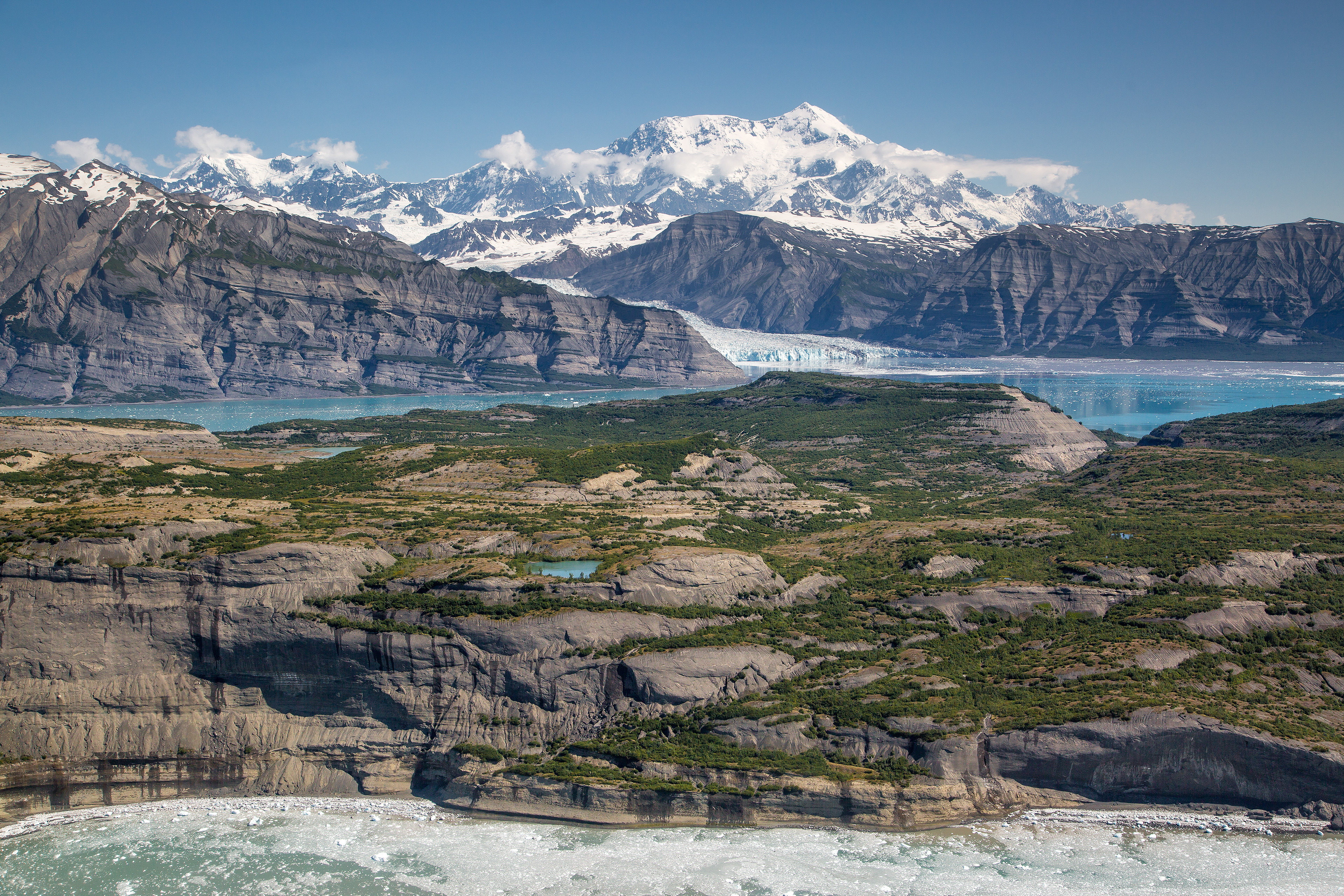
Wrangell-St. Elias National Park weather is not one thing. It's a dozen different climates happening at once across a landscape the size of Yellowstone, Yosemite, and Switzerland combined. The single most important truth is that the forecast for the visitor center in Copper Center is almost meaningless for what you'll face at the Kennecott Mines or on a high alpine pass. You can have rain at sea level, sun in the valley, and a whiteout blizzard on the 18,008-foot peak of Mount St. Elias - all in the same afternoon. Most first-time visitors are caught off guard by the sheer scale of the vertical relief, which dictates everything from temperature to precipitation type. This isn't a park where you check one weather app; it's where you plan for multiple realities and pack for all of them. For a broader look at navigating this immense place, our complete visitor guide covers the essentials.
Wrangell-st. Elias National Park Weather
9 min read
Plan for 12 microclimates in a park bigger than Yellowstone. From Copper Center to Mount St. Elias, get the 2026 guide to packing and forecasts that matter.
The Weather Reality
The park's weather is governed by its extreme topography. Moist air sweeps in from the Gulf of Alaska, hits the coastal mountains, and gets wrung out. This creates a pronounced rain shadow. The interior valleys around McCarthy and Kennecott are significantly drier than the coastal flanks. A sunny, 70-degree day in McCarthy can coincide with a cold, soaking drizzle just 30 miles away as you cross a pass.
Altitude is the other dictator. The temperature drops roughly 3 to 5 degrees Fahrenheit for every 1,000 feet of elevation gain. That means a pleasant 65°F day at the 2,000-foot trailhead becomes a 35°F experience with potential snow at 8,000 feet. Rangers will tell you that hypothermia is a summer risk here, not just a winter one.
The official forecast for "Wrangell-St. Elias" typically reflects conditions at park headquarters in Copper Center, which sits in a broad, interior valley. It's a starting point, but it won't tell you about the katabatic winds roaring off the glaciers in the evening or the localized fog that can sock in a river canyon for days. Experienced visitors know to look at multiple point forecasts: one for McCarthy, one for higher elevations if heading into the backcountry, and a general outlook for the Gulf of Alaska to see what systems are lining up.

Month by Month
Visitor facilities are seasonal. As of 2026, the main visitor centers at Copper Center and Kennecott typically open around late May and close by mid-September. The Slana Ranger Station shows year-round hours, but always call ahead. The park lands themselves never close.
May & Early June
Temperatures range from overnight lows in the 30s to daytime highs in the 50s and low 60s. Snow is still melting at lower elevations, and higher trails are buried. This is mud season. Rivers run high, brown, and dangerously cold with glacial silt and snowmelt.
What's open: Some roadside facilities may open late in the period. The McCarthy Road is often passable but rough.
Crowd level: Very low. You'll have the place to yourself, but for good reason.
Wildlife: Bears are active and emerging. Migratory birds return.
Trail conditions: Lower valley trails may be wet, muddy, or partially snow-covered. Stream crossings are hazardous.
Worth considering for: Solitude, photography of snow-capped peaks against green valleys, and seeing the landscape awaken.
Challenging because: Unpredictable weather, limited services, persistent bugs as temperatures rise, and significant avalanche danger in the mountains.
Late June, July, & August
This is the core visitor season. Valley temperatures can reach into the 70s, with nights dipping into the 40s and 50s. At higher elevations, expect 40s and 50s during the day, with freezing nights. Afternoon showers are common, often building into thunderstorms by late July.
What's open: All visitor centers, most concession operations in Kennecott, and guided tours.
Crowd level: Moderate to high in accessible areas like Kennecott. The backcountry remains quiet due to the park's size.
Wildlife: Peak activity. Moose with calves, Dall sheep on high slopes, bears foraging.
Trail conditions: Most trails are snow-free up to about 3,500-4,000 feet by July. Higher alpine routes may hold snowfields well into August.
Worth considering for: Reliable access, the best chance for dry weather windows, full services, and peak wildflowers in July.
Challenging because: Mosquitoes and flies are at their worst in July. Afternoon storms can roll in quickly. This is also when the park sees most of its search-and-rescue calls from underprepared hikers.
September & October
The golden months. September days can be crisp and sunny, with highs in the 50s and 60s and nights plunging into the 20s and 30s. The first significant snows dust the high country. October brings winter; highs may only reach the 40s, with frequent frosts.
What's open: Facilities begin closing after Labor Day. The Kennecott visitor center typically closes by early September. Always verify.
Crowd level: Drops dramatically after early September.
Wildlife: Rutting season for moose and caribou. Bears enter hyperphagia, feeding aggressively.
Trail conditions: Excellent in early September - dry trails, fewer bugs. Snow begins accumulating at higher elevations by mid-month, closing alpine routes.
Worth considering for: Fall colors (peak mid-to-late September), light, no bugs, and a sense of having the wilderness to yourself.
Challenging because: Rapidly shortening daylight, cold nights, and the constant potential for an early winter storm that can change travel plans instantly.
November through April
Winter. Temperatures routinely sit below freezing, with lows reaching -20°F or colder in the interior valleys. Snow accumulates by the foot, not the inch. Coastal areas see more precipitation, often as heavy, wet snow or rain.
What's open: The Slana Ranger Station may have limited hours. No visitor services. The McCarthy Road is not maintained for winter travel.
Crowd level: Minimal. Visitation is for experienced winter recreationists only.
Wildlife: Quiet. Tracks of lynx, wolf, and wolverine tell the story.
Trail conditions: Everything is a snow trail. Travel is by ski, snowshoe, or snowmobile where permitted.
Worth considering for: Extreme solitude, pristine snowscapes, aurora viewing on clear nights, and challenging winter expeditions.
Challenging because: Severe cold, avalanche danger, limited daylight, and zero services. This is expedition-level planning.

Best Times for Specific Activities
Hiking the High Country
Your window is narrow. For trails that venture above treeline, aim for late July through early September. Even then, expect to encounter lingering snowfields on north-facing slopes. Early August usually offers the most stable weather and the least snow obstruction.
Wildlife Viewing
Late May through September offers the best chances, but timing varies by species.
- Bears: Best seen in July and August along salmon streams and in berry patches. Fall (September) brings heightened activity as they fatten up.
- Dall Sheep: Look for them on high, rocky slopes from July to September. They descend to lower elevations in spring and fall.
- Moose: Most visible in spring (May-June) in wetlands and during the fall rut (September).
- Caribou: Herds move through the park; sightings are unpredictable but more likely in late summer and fall in open tundra.
Wildflowers
Peak bloom hits the valleys and lower slopes in mid-to-late July. Fireweed, lupine, and arctic poppies create vivid displays, especially in areas that were previously glaciated.
Fall Colors
The tundra and deciduous shrubs (willow, birch) turn brilliant gold and red. The peak is typically mid-to-late September. The aspen groves in the interior valleys follow shortly after.
Stargazing & Aurora
For the Northern Lights, you need dark skies and solar activity. September through March provides the long, dark nights. The trade-off is bitter cold. For Milky Way viewing without extreme cold, late August and September offer a good balance of darkness and tolerable temperatures.
Winter Sports
The season for reliable snow cover runs from November through April. January and February offer the most consistent cold and snow conditions for ski touring and snowshoeing, but also the most challenging environment.

What to Pack by Season
Forget generic lists. Wrangell-St. Elias demands specific preparation.
Summer (June-August):
- Layering System: A moisture-wicking base layer, insulating mid-layer (fleece or puffy), and a waterproof/windproof shell are non-negotiable. You'll use them all in one day.
- Sturdy Footwear: Waterproof hiking boots with good ankle support for rocky, wet trails.
- Bug Defense: A head net is not overkill for July. Use permethrin on clothing and reliable DEET or picaridin.
- Sun Protection: High UV intensity at altitude. Sunglasses, hat, and strong sunscreen.
- Bear Spray: Carry it where it's instantly accessible, not buried in your pack.
Fall (September-October):
- Everything from summer, but swap the light puffy for a heavier insulated jacket.
- Warm Hat and Gloves: Mornings start cold.
- Traction Devices: Microspikes can be essential for early morning ice on trails or if you encounter unexpected snow.
- Extra Food/Fuel: Weather windows can close, forcing you to wait out a storm.
Winter (November-April):
- Expedition-grade gear. This means a -20°F sleeping bag if camping, a four-season tent, serious synthetic or down insulation, and vapor barrier liners for boots.
- Communication & Navigation: Satellite messenger (e.g., Garmin inReach), map, compass, GPS. Cell service is nonexistent.
- Avalanche Gear (if traveling in avalanche terrain): Beacon, probe, shovel, and the training to use them.

What the Forecast Doesn't Tell You
- Glacier Wind: On sunny days, cold air pours down off the ice. The temperature can drop 15 degrees in minutes when you step into the outflow from a glacier like the Kennicott or Root. That picnic spot that was perfect becomes miserable.
- River Dynamics are Constant: The alert about the Lakina River landslide is a prime example. Rivers here change course, undercut banks, and create new logjams overnight. A crossing that was safe one day can be impassable the next. This applies to packrafting and fording on foot.
- The "Dry" Interior Still Gets Rain: While the Copper River Basin is in a rain shadow, "dry" is relative. You can still get a week of steady, cold rain in August that soaks everything and makes trails slick.
- Sun Angle is Low: Even in summer, the sun travels a low arc. Deep valleys and mountain faces lose direct sunlight by mid-afternoon, causing a rapid temperature drop. Plan your hike timing accordingly.
- Dust is a Thing: On the McCarthy and Nabesna Roads, dry spells turn the gravel into fine, billowing dust that coats everything inside your vehicle if you follow too closely. Roll up windows and use your headlights.
- Weather Moves Fast: You can watch a storm system envelop a mountain range from the valley floor. It might be sunny where you are, but your planned route could be in a cloud. Have a Plan B.
- Freezing Level is Key: For any hiking or climbing, the most critical forecast detail is the freezing level. If it drops to 4,000 feet overnight, that rain at the trailhead was snow on your intended route.
Practical Takeaways
- Plan for Three Seasons in a Day, even in July. Your pack should always have insulation, rain gear, and extra food.
- The best weather window for a balance of access, comfort, and reliable conditions is mid-August to mid-September. The bugs are gone, the crowds thin, and the light is spectacular.
- Ignore the valley forecast for high-country plans. Always seek out elevation-specific weather resources and assume conditions will be colder, windier, and wetter.
- Your vehicle is part of your gear. On the park's rough roads, a full-size spare tire, extra fuel, and emergency supplies are as important as your hiking boots.
- Waterproof your essentials. Use dry bags or ziplocks for your sleeping bag, clothes, and electronics. Sudden rain or an unplanned stream crossing can happen anywhere.
- Check in with a ranger. Before heading out, especially on backcountry trips, stop at a visitor center. They have the latest on river crossings, trail conditions, and bear activity that hasn't made it to the website yet.
- Respect the scale. A weather delay here isn't a minor inconvenience. It can mean waiting multiple days for a river to drop or for a flight to get in. Build flexibility into your itinerary.
Wrangell-St. Elias doesn't cater to casual visits. Its weather demands respect and preparation. Get that right, and you're rewarded with a raw, powerful wilderness experience few other places on earth can match. For detailed planning on hiking trails or camping options within this immense climate zone, our other guides can help you focus your trip.
For more information, see our complete National Park & Preserve Guide.
Related: wrangell-st. elias national park guide
Related: wrangell-st. elias national park lodges guide
Sources
- Official source: NPS — Wrangell-St. Elias National Park nps.gov/wrst/index.htm
Photo Gallery
More to Explore

Acadia National Park: Carriage Roads, Cadillac Mountain & 2026 Guide
Discover carriage roads, Cadillac Mountain, and rugged Maine coast. Complete 2026 guide to Acadia National Park — trails, fees, lodging, permits, and what rangers recommend.

Grand Canyon Hiking Trails: Day Hikes, Water Sources & Rim to Rim
Compare Grand Canyon hiking trails: Bright Angel, South Kaibab, Hermit, Grandview, and rim to rim, with distances, elevation, water stops, and trailhead access for each.

Best of Glacier Bay National Park
The best of Glacier Bay is reached by boat: ranger-led day tours up the bay to the tidewater glaciers. What's worth it, how to book, and when to go (2026).

White Sands Backcountry Camping: Closed for 2026 — What to Know
As of 2026, backcountry camping at White Sands National Park is closed for site rehabilitation. What that means, and where to camp nearby instead.

Guadalupe Mountains National Park Weather: Weather
Guadalupe Mountains National Park: weather guide guide updated 2026. Practical visitor information, reservations, and seasonal tips worth bookmarking before

Best of Cuyahoga Valley National Park: Best Things to Do
Seeing a Cleveland Orchestra concert with the woods as your backdrop is a uniquely Cuyahoga Valley experience.
Sign in to join the conversation.
Sources & Attribution
Location data courtesy of the National Park Service (U.S. Department of the Interior). NPS data is public domain. Official NPS page.
Images: NPS; NPS; NPS; NPS; NPS.
Map data © OpenStreetMap contributors.
Park operations alerts: NPS.gov · Weather and weather hazards: National Weather Service · Live conditions.
Information may change. Always verify fees, hours, and conditions directly with the official source before visiting.
Did this guide help? Share it with a friend.