What Hiking Here Actually Means
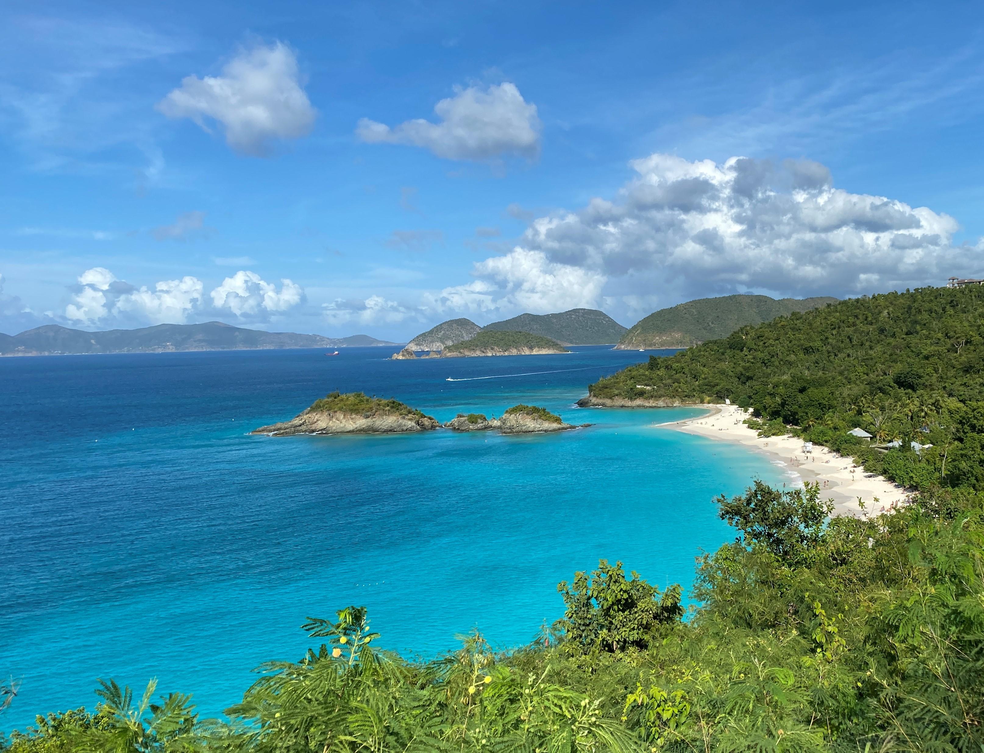
Most people come to St. John for the beaches. The white sand and turquoise water get all the attention. But two-thirds of this island is national park, and the trails here offer something the beaches cannot: context.
13 min read
Complete 2026 hiking guide for Virgin Islands National Park. Trails, difficulty ratings, seasonal conditions, and practical tips for every skill level.
This article contains affiliate links — we may earn a small commission at no extra cost to you.
Most people come to St. John for the beaches. The white sand and turquoise water get all the attention. But two-thirds of this island is national park, and the trails here offer something the beaches cannot: context.
Hiking in Virgin Islands National Park means walking through layers of history that most visitors never see. The trails pass through former sugar plantations, past ancient Taino petroglyphs, and along coastlines where the tradewinds carry salt spray up from the reef. The terrain is nothing like mainland hiking. You are never more than a few miles from the ocean, but the humidity and heat will push you harder than the elevation numbers suggest. First-time visitors from temperate climates consistently underestimate how much water they need and how slow the trail miles go.
The common mistake is treating these as casual strolls. They are not. A 3-mile trail here demands the same preparation as a 6-mile trail in the Rockies. The difference is the reward: you end at a reef you can snorkel, a 1,000-year-old petroglyph, or a plantation ruin where the sugar mill still stands. For a full breakdown of everything the park offers beyond hiking, check the complete visitor guide for Virgin Islands National Park.

If you do one hike on St. John, this is it. The Reef Bay Trail is the most complete hiking experience in the park because it combines history, archaeology, and the signature terrain of the island into a single 4.6-mile round trip.
Distance: 4.6 miles round trip (2.3 miles each way)
Elevation Gain: Approximately 900 feet descending, then 900 feet climbing back out
Trailhead & Parking: The trailhead is located on Centerline Road (Route 10), about 3.5 miles east of Cruz Bay. The parking lot holds roughly 15 vehicles. It fills by 8:30 AM during peak season (December through April). Overflow parking is not available at the trailhead - you will need to backtrack to a pullout or arrange a taxi. Early morning is your best bet for a spot.
The Trail: The trail begins at the top of the island and descends through a lush tropical forest that transitions into dry forest and finally coastal vegetation. The surface is mostly packed dirt with exposed roots and occasional rock steps. The first mile is the steepest section - your knees will feel it on the descent and your quads on the return climb. About halfway down, you will pass the remains of the Reef Bay sugar plantation, including the great house foundation, factory ruins, and a stone sugar mill. Rangers will tell you this is the most intact plantation complex on the island. Continue past the ruins to reach the petroglyph site - a rock face carved by the indigenous Taino people with figures of turtles, fish, and human-like forms. The trail narrows here as it approaches the stream.
The Moment: Standing in front of the Taino petroglyphs, water trickling over the carved stone, with the sound of the reef breaking offshore. You are looking at art that is 500 to 1,000 years old, carved by people who lived here before Columbus.
What Most Underestimate: The return climb. It is 900 feet of steady uphill in full humidity. The official website mentions the elevation, but it doesn't convey how the heat sits in the forest canopy. Pack extra water for this stretch - you will need at least 1.5 liters per person for this hike alone. Also, the trail can be slick after rain. The current trail alert notes that rain may cause trails to be slick and overgrown - this applies specifically to the rocky sections near the petroglyphs.
Best Time: Start at 7:30 AM. You want to be at the petroglyphs by 9:00 AM before the tour groups arrive and before the midday heat settles in. The guided ranger hike (offered seasonally) departs at 9:00 AM and includes the boat ride back from Reef Bay - check at the visitor center for the 2026 schedule.

Distance: 1.2 miles round trip (or 0.6 miles one way to Salomon Beach)
Elevation Gain: 150 feet
Trailhead & Parking: Starts directly from the Virgin Islands National Park Visitor Center in Cruz Bay. No parking issue - you walk from the ferry or the visitor center lot. The parking situation here is actually fine if you arrive before 9:00 AM, but street parking in Cruz Bay fills quickly.
The Trail: This is the warm-up hike. It climbs briefly from the visitor center, crosses a ridge with views of Cruz Bay, then descends to Salomon Beach or continues to Honeymoon Beach. The surface is compacted dirt with a few rocky sections. It is short but steep enough to get your heart rate up. The trail narrows here near the ridge crest.
The Moment: The first glimpse of Salomon Beach from the trail - a crescent of white sand with no buildings visible in either direction. You can be on that beach 20 minutes after stepping off the ferry.
What Most Underestimate: How exposed the ridge section is. Midday sun here is intense. There is almost no shade for the middle third of the trail. Cell service drops out at the beach, so download your map or screenshot the trail.
Best Time: Late afternoon (4:00-5:00 PM) when the sun angles through the trees and the beach crowd has thinned.
Distance: 2.4 miles round trip from Cruz Bay to the summit
Elevation Gain: 650 feet
Trailhead & Parking: Starts at the National Park Visitor Center in Cruz Bay. Same walk-up access as Lind Point. No dedicated trailhead parking - use the visitor center lot or street parking.
The Trail: This is the quickest way to get above the island. The trail climbs steadily through dry forest, passing the ruins of an old sugar plantation about halfway up. The surface is mostly rock and dirt with some loose gravel sections on the steeper pitches. The elevation gain is worth it - the summit offers a 360-degree view of St. John, St. Thomas, and the British Virgin Islands to the east. From this overlook you can see all the way to Jost Van Dyke on a clear day.
The Moment: Standing at the stone overlook at the top, watching the ferries cross Pillsbury Sound between St. John and St. Thomas, with the British Virgin Islands lined up on the eastern horizon.
What Most Underestimate: The trail continues past the main overlook to another peak called Margaret Hill, adding another 0.8 miles and 200 feet of elevation. Most people stop at the first summit and miss the better view. Keep going.
Best Time: Early morning (6:30-7:30 AM) for the sunrise light and cooler temperatures. The sun comes up over the British Virgin Islands, and the light on the water is worth the early start.
Distance: 2.2 miles round trip
Elevation Gain: 200 feet (but feels like more due to the terrain)
Trailhead & Parking: Located at the far end of Salt Pond Bay, on the southeastern side of the island. The Salt Pond Bay parking lot holds about 20 vehicles and fills by 9:00 AM on weekends. Overflow parking is available along the road, but expect a longer walk to the trailhead. Early morning is your best bet for a spot.
The Trail: This is the most exposed trail in the park. The path follows a rocky ridge out to the Ram Head peninsula with no shade whatsoever. The surface is weathered volcanic rock - watch your footing, especially where the rock is crisscrossed with crevices. The wind here is constant and can be strong enough to knock you off balance on gusty days. The trail ends at a flat rock promontory overlooking the Caribbean and the uninhabited islands to the south.
The Moment: Standing at the tip of Ram Head with the ocean on three sides, waves crashing against the rocks 100 feet below, and not a single building visible anywhere in the 180-degree view.
What Most Underestimate: The wind and the sun. There is zero shade. Bring a hat, sunscreen, and at least 1 liter of water per person. The trail conditions alert mentions overgrown sections - this is the trail where that matters most, as the vegetation along the ridge can be scratchy.
Best Time: Late afternoon (3:00-5:00 PM) for the angle of the light and slightly lower temperatures. The hike takes about 1.5 hours, and you will want to sit at the point and watch the sun start its descent.
Distance: 2.2 miles round trip (one-way to the cay)
Elevation Gain: Minimal - maybe 50 feet
Trailhead & Parking: Park at the Annaberg Plantation lot on the North Shore Road. The lot holds about 25 cars. Fill by 9:30 AM most days. The parking situation here is tight because people also park for the Annaberg site.
The Trail: This is a flat, easy trail that follows the shoreline from the Annaberg parking area east along Leinster Bay. The surface is packed sand and gravel. Keep an eye out for hermit crabs crossing the trail - they are everywhere here. The trail ends at Waterlemon Cay, a small island just offshore that has some of the best snorkeling in the park. The trail itself is not the point - the snorkeling is. But the walk along the bay with the water on one side and the hills on the other is as pleasant a mile as you will find anywhere.
The Moment: Wading into the water at Waterlemon Cay and putting your mask down. The coral reef here is alive with sea turtles, rays, and hundreds of species of reef fish. The snorkeling is better than most of the Caribbean.
What Most Underestimate: The current around the cay. It can be strong enough to push you past the snorkeling area. Swim against it on your way out so the return with the current is easier. Also, the trail can be very hot by late morning with limited shade.
Best Time: 8:00 AM - you want to finish the hike and start snorkeling before 10:00 AM when the sun is high and the water clarity is best.
Distance: 0.5 miles (interpretive loop)
Elevation Gain: Minimal
Trailhead & Parking: Same lot as Leinster Bay Trail. Park at the Annaberg Plantation parking area.
The Trail: This is a short, paved loop through the remains of the Annaberg sugar plantation. It is not a wilderness hike, but it is one of the most important walks on the island because it tells the story of enslaved labor on St. John. The trail passes the ruins of the sugar mill, the boiling house, and the windmill tower. Keep an eye out for the interpretive signs that explain how sugar was processed and who did the work. Rangers give free cultural demonstrations here several times per week - check the schedule at the visitor center. The trail narrows here in places where the ruins abut the path.
The Moment: The view from the windmill platform across Leinster Bay. It is beautiful. It is also the same view the enslaved workers saw every day. The contrast between the beauty and the history is what stays with you.
What Most Underestimate: How much time to budget. The trail is short, but the cultural demonstrations run 30-45 minutes, and you should budget another 20-30 minutes for the self-guided tour. Most visitors underestimate the emotional weight of this place.
Best Time: When a cultural demonstration is scheduled - typically Tuesday and Thursday mornings.

The tradewinds that blow east to west across the tropical Atlantic define the hiking experience here more than any other weather factor.
Winter (December to March): This is the high season. Stronger winds and less rain mean trails are generally dry and in good condition. The downside is crowds - expect company on Reef Bay and Ram Head by 9:00 AM. Temperatures range from the mid-70s to low 80s. The winter swell can make beach access at some trail ends (Reef Bay, Salt Pond) rough.
Spring (April to May): The sweet spot. Crowds thin after Easter. Rain increases slightly but not enough to close trails. The vegetation is green and the flowers are out. Trail conditions are at their best.
Summer (June to September): This is when hiking in Virgin Islands National Park gets serious. Higher temperatures, higher humidity, and more rain. Trails can be slick and overgrown - the current trail alert specifically warns about this. The rain also means more mosquitoes. Start before 7:00 AM or don't start at all. The payoff is fewer people and greener vegetation.
Hurricane Season (June to November): The official hurricane season. Check the forecast frequently. Most trails close during storm warnings. The real risk is not hurricanes themselves but the heavy rain they can bring - trails become slippery and stream crossings can rise quickly. If a storm passes even 100 miles away, expect wet, slick trails for two to three days afterward.

Parking strategy: Every trailhead on St. John fills early. The pattern is consistent - lots fill between 8:30 and 9:30 AM December through April. If you arrive after 9:00 AM, you will likely be parking along the road or skipping the hike entirely. The exception is Lind Point and Caneel Hill, which start from the visitor center in Cruz Bay - those are walkable from anywhere in town.
Cell service: Verizon and AT&T both work in Cruz Bay and along the North Shore Road. Cell service drops out at most trailheads once you are 100 yards into the forest. Reef Bay, Ram Head, and Leinster Bay all lose signal. Download maps and screenshots of trail info before you leave Cruz Bay.
Water sources: There are no potable water sources on any trail. The visitor center has a filling station. Bring everything you need.
Ranger station for trail conditions: Stop at the visitor center at 1300 Cruz Bay Creek before heading out. The staff can tell you current conditions on specific trails. If you see an issue on trail, report it to viis_interpretation@nps.gov.
Ferry timing: There are no airports on St. John - you fly into St. Thomas (STT), then take the ferry from Redhook to Cruz Bay. The passenger ferry runs every hour. The car barge takes about 45 minutes. Factor this into your timing - a 7:00 AM start on-trail means catching the 6:00 AM ferry from Redhook.
The gear list for St. John Virgin Islands hiking is different from what you carry in a mainland national park.
Footwear: Trail runners with good tread are better than heavy boots. The terrain is mostly packed dirt and rock - boots are overkill and your feet will get hot. The one exception is wet conditions, where the extra ankle support helps on slick rock. Keen, Merrell, or Salomon trail runners work well here.
Water: Minimum 1 liter per hour of hiking. For Reef Bay, that means 2-3 liters per person. For Ram Head with no shade, 2 liters minimum. There is no potable water on any trail.
Sun protection: A wide-brimmed hat, long-sleeved lightweight shirt, and reef-safe sunscreen. The UV index here is extreme - you can burn in 15 minutes on Ram Head or Caneel Hill.
Navigation: Download maps before you arrive. Cell service is unreliable on most trails. The AllTrails app or paper maps from the visitor center will keep you on track.
The thing most people forget: A dry bag for your phone and valuables. Many hikes end at a beach where you will want to snorkel. Salt water destroys phones. A $10 dry bag saves you $800.
Mosquito repellent: Essential June through October. The trails through the forest (Reef Bay, Caneel Hill) can be thick with mosquitoes after rain. DEET or picaridin, not the natural stuff - it doesn't work well enough here.
For more information, see our complete National Park Guide.
Related: st john virgin islands hiking guide
Related: virgin islands hiking guide
What experienced visitors bring to Virgin Islands National Park Hiking: Hiking in (2026 Guide)
Links may earn us a commission at no extra cost to you. We only recommend gear we believe in.
Hiking Essentials
Hydration Pack (3L)
Hands-free water for long trail days
Trekking Poles (Pair)
Save your knees on steep descents
Hiking Boots (Ankle Support)
Sturdy footwear for rocky, uneven trails
Sun & Heat Protection
Wide-Brim Sun Hat
Full coverage UPF 50+ protection at altitude
Insulated Water Bottle (32oz)
Keeps water cold in desert heat all day
Winter Gear
Microspikes / Traction Devices
Essential for icy rim trails in winter months
Packable Down Jacket
Lightweight warmth that stuffs into a pocket

Discover carriage roads, Cadillac Mountain, and rugged Maine coast. Complete 2026 guide to Acadia National Park — trails, fees, lodging, permits, and what rangers recommend.

Compare Grand Canyon hiking trails: Bright Angel, South Kaibab, Hermit, Grandview, and rim to rim, with distances, elevation, water stops, and trailhead access for each.

The best of Glacier Bay is reached by boat: ranger-led day tours up the bay to the tidewater glaciers. What's worth it, how to book, and when to go (2026).

As of 2026, backcountry camping at White Sands National Park is closed for site rehabilitation. What that means, and where to camp nearby instead.

Guadalupe Mountains National Park: weather guide guide updated 2026. Practical visitor information, reservations, and seasonal tips worth bookmarking before

Seeing a Cleveland Orchestra concert with the woods as your backdrop is a uniquely Cuyahoga Valley experience.
Sign in to join the conversation.
Location data courtesy of the National Park Service (U.S. Department of the Interior). NPS data is public domain. Official NPS page.
Images: NPS; NPS; NPS; NPS; NPS.
Map data © OpenStreetMap contributors.
Park operations alerts: NPS.gov · Weather and weather hazards: National Weather Service · Live conditions.
Information may change. Always verify fees, hours, and conditions directly with the official source before visiting.
Did this guide help? Share it with a friend.