The Cowles Bog Trail is the best all-around hike at Indiana Dunes National Park, a 4.5-mile loop that delivers lake views, solitude, and the park's signature dune ecology.
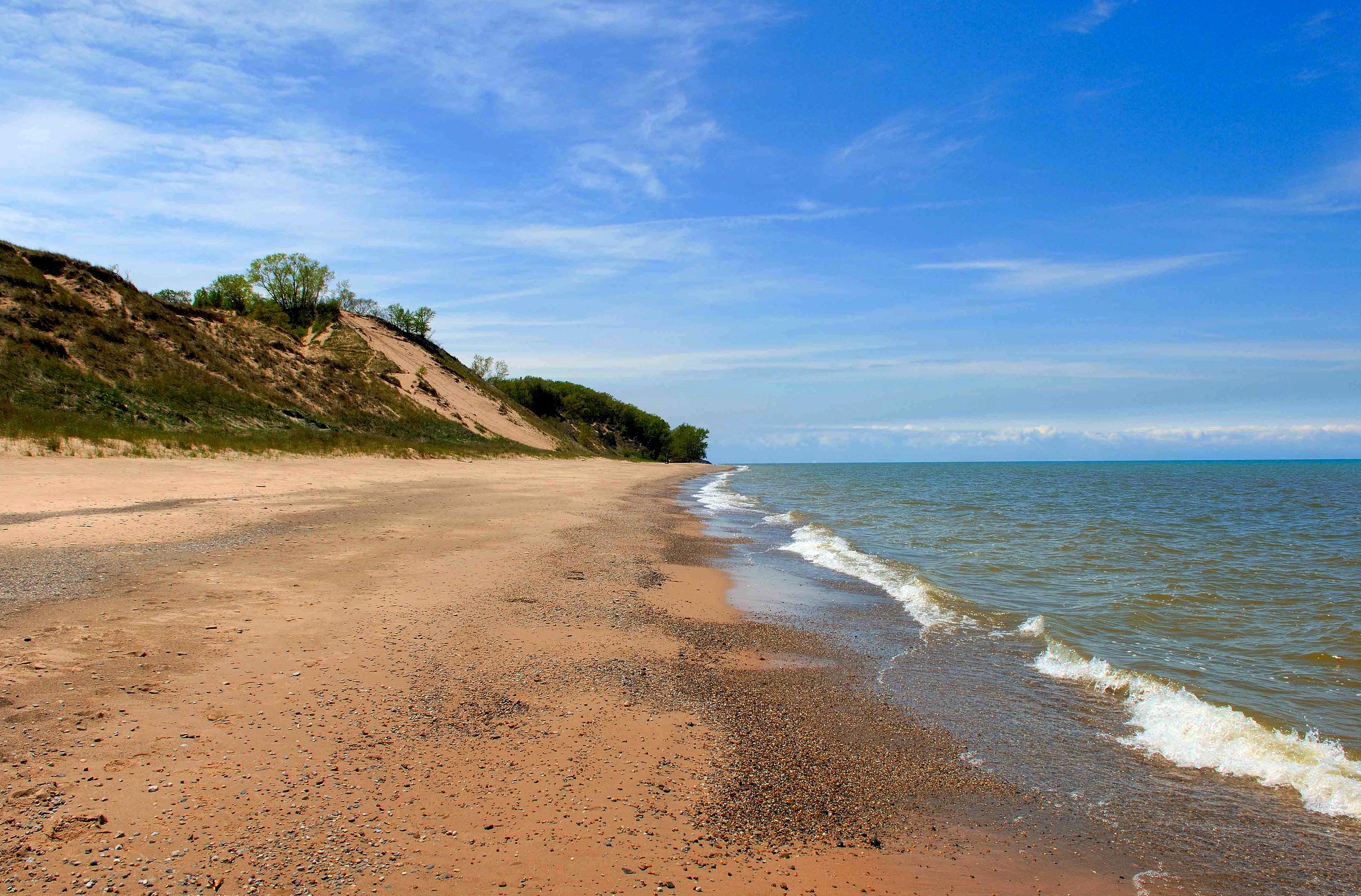
NPS via NPS.gov (Public Domain)
Indiana Dunes National Park Hiking: Best Hike at (2026 Guide)
13 min read
Hiking Guide
Discover the best hike at Indiana Dunes National Park: the Cowles Bog Trail, a 4.5-mile loop with lake views and solitude. Plan your visit with our 2026 guide.
This article contains affiliate links — we may earn a small commission at no extra cost to you.
What Hiking Here Actually Means
Hiking at Indiana Dunes is not like hiking in the Rockies or the Appalachians. The elevation gain is modest - the highest dune rises maybe 200 feet above the lake - but loose sand changes everything. A mile on packed trail might take you 15 minutes. A mile climbing a dune face in soft sand can take 40, and your heart rate will tell you about it. Experienced visitors consistently underestimate this. Visitors from flat states get humbled by the first real dune ascent. The park's 14 distinct trail systems cross more than a dozen habitat types, from Great Lakes shoreline to black oak savanna to tamarack bog. In a single day you can walk beach, forest, prairie, and wetland.
The trails are generally well-marked, but the sand shifts, and some junctions at the dunes can be confusing at first glance. Cell service drops out at several points along the shoreline and deeper into the Glenwood Dunes section. Download maps before you arrive.

The Signature Trails
Cowles Bog Trail: The Best All-Around Hike
This is the trail rangers will tell you to do first. It hits almost every habitat in the park and ends at a quiet stretch of Lake Michigan beach that most visitors miss.
Distance: 4.5 miles loop
Elevation Gain: Roughly 150 feet, but all of it in loose sand
Trailhead & Parking: The Cowles Bog parking lot on Mineral Springs Road, just north of U.S. 12. The lot holds maybe 30 cars. By 9 AM on summer weekends it is full. Overflow parking is at the Indiana Dunes State Park lot a mile south - you'll need to add the walk.
The Trail: The loop starts through a thick forest of oak and sassafras, then opens into a sedge meadow where the trail is boardwalk for a stretch. You cross a small bridge over a marsh channel, then enter the dune succession zone. This is where the work begins. The trail climbs a steep dune face on soft sand - think staircase without the stairs. At the top you get the lake view, then the trail drops through more dunes to the beach. The beach section runs about half a mile before re-entering the woods and looping back. Surface changes from packed dirt to boardwalk to exposed sand to beach gravel and back.
The Moment: The view from the top of the dune before descending to the beach. You see the lake stretch to the horizon, the Chicago skyline faint on clear days to the northwest, and the dune ridge curving away behind you. The trail narrows here, and the wind picks up fast - keep your hat secure.
What Most Underestimate: That "moderate" rating on the NPS site means something different in sand. The dune climb is short but punishing. A few hikers turn around at the beach and go back the same way rather than completing the loop - don't do that. The loop back through the woods is the easier half and the more interesting one, with views over the marsh.
Best Time: Early morning, before the sand heats up and the beach crowds arrive. Spring and fall are ideal. Summer is doable but hot - bring extra water.
West Beach Succession Trail: The Short Educational Route
This gets called the best short hike at Indiana Dunes National Park for anyone who wants to understand how dunes actually form. It's a self-guided trail with interpretive signs explaining the stages of dune succession.
Distance: 0.75 miles one way (1.5 miles out-and-back)
Elevation Gain: 80 feet
Trailhead & Parking: West Beach entrance off County Line Road. The lot is large - holds a couple hundred cars - but on peak summer weekends it can fill by 10 AM. A parking fee applies for the beach area. The trail is just past the bathhouse and the foot of the beach stairs.
The Trail: The trail climbs steadily up a large foredune, then drops into a "dune slack" - a low wet area - then climbs again to a higher dune ridge. The interpretive posts mark each stage: open sand, marram grass colonization, cottonwood pioneers, then the black oak forest that takes over after a century or more. It is educational without feeling like a classroom. The surface is entirely sand, packed in some sections and loose in others.
The Moment: Halfway up the second dune, turn around and look back. You see the beach, the lake, and the trail cutting through grass that is literally holding the dune in place. It makes the ecology real in a way a sign cannot.
What Most Underestimate: How much the wind affects you on the exposed dunes. On a 70-degree day with 20 mph wind off the lake, you will want a jacket. Also, the beach at the bottom gets heavy use - the solitude factor on this trail is higher if you go early.
Best Time: Late April through June for the dune grasses greening up. September and October for cooler hiking with fewer people. The West Beach area closes at 9 PM daily, so plan around that.
1966 Hiking Challenge: For the Dedicated
Not a single trail but a collection. The 1966 Hiking Challenge is 19 hikes covering 66 miles total, designed to celebrate the year the park was established as Indiana Dunes National Lakeshore. Completing it earns you a patch and bragging rights.
Distance: 66 miles across 19 segments
Elevation Gain: Varies by segment, but cumulative is well over 2,000 feet across the park
Trailhead & Parking: Each segment starts at a different trailhead. The park's visitor center on IN-49 sells the guidebook and log. Most segments use the established trail systems - Glenwood Dunes, Cowles Bog, Pinhook Bog, and the Calumet Trail among them.
The Trail: Segments range from 2-mile strolls through wetlands to 6-mile treks along the dunes. Some trails are flat and shaded; others climb soft sand with no cover. The challenge is meant to be completed over multiple visits, not in one weekend, though some people do it in a push - camp nearby and make a multi-day project of it.
The Moment: Each segment has its own highlight, but the Glenwood Dunes section in late afternoon light, with the low sun slanting through the oak canopy, is the one most finishers name.
What Most Underestimate: The logistics. Nineteen hikes means nineteen trailheads. Some have tiny lots. You need to think about shuttling cars on the road walks or accepting that some segments require backtracking. Also, the challenge does not include state park trails - only NPS trails - so do not confuse the two.
Best Time: Spring and fall are ideal for the full challenge. Summer heat on the exposed dune segments is punishing, and some trails get overgrown by late July.
Diana Dunes Dare: Quick, Hard, and Worth It
Named for Alice Mabel Gray, who lived alone in the dunes in the early 1900s. The dare is a hiking challenge - climb a specific dune within a time limit. The ghost story angle adds flavor, but the hike itself stands on its own.
Distance: 40 minutes to 1 hour 40 minutes depending on pace
Elevation Gain: About 100 feet in soft sand, but it is steep
Trailhead & Parking: Near the Indiana Dunes State Park entrance on U.S. 12. Parking is available at the state park lot for a separate fee. The trailhead is signed.
The Trail: This is mostly a dune climb on loose sand. You go up, then down, then up another dune. The park has a suggested time limit - complete within 40 minutes for the "dare" designation - but the real joy is the view from the top. On clear days you can see the entire southern curve of the lake.
The Moment: The silence at the top. The dunes block the road noise, and if the wind is low, you hear nothing but the Lake Michigan surf a quarter mile away.
What Most Underestimate: The time goal. Unless you are fit and used to sand hiking, shoot for the 60-minute mark. Trying for 40 your first time will leave you frustrated and breathing hard halfway up.
Best Time: Winter and early spring, when the low sun paints the dune ridges in warm light and the sand is cold enough to hold your footing better. Summer sand gets loose and hot.
Glenwood Dunes Trails: The Horseback and Long-Distance Option
Distance: 6.5 miles of trail if you hike the full system, with connections to longer routes
Elevation Gain: 50 feet total - mostly flat through ancient dune formations
Trailhead & Parking: Glenwood Dunes trailhead on County Line Road. The lot is medium-sized, and because this trail sees less beach traffic, it fills slower than West Beach or Cowles Bog lots.
The Trail: These are the park's only equestrian trails, meaning they are wider than most hiking trails and packed harder. You walk through a mature oak forest that has been stabilizing these old dunes for centuries. The surface is sand mixed with leaf litter and pine needles - better footing than any beach dune. The trail system connects to the Little Calumet River Trail for extended mileage.
The Moment: About two miles in, the forest opens into a savanna where the oaks spread wide and the ground is covered in blueberry bushes. In late June, the berries are ripe.
What Most Underestimate: That this is a multi-use trail. You share with horses. Step aside for them - they have the right of way, and a horse passing close on a narrow trail is a real experience.
Best Time: Any time the trail is dry. After rain, the sand holds up fine, but some connecting sections turn muddy. Avoid the Glenwood section of the Marquette Greenway from April through December 2026 due to construction closures.
Pinhook Bog Trail: The One Nobody Does
Distance: 1 mile boardwalk loop
Elevation Gain: None
Trailhead & Parking: Off U.S. 12 near Waverly. The lot is small and easy to miss. Drive slow and watch for the sign.
The Trail: A floating boardwalk through a quaking bog. The trail crosses open water, sphagnum moss mats, and carnivorous plants - pitcher plants and sundews - that you can see up close from the boardwalk. This is a fragile ecosystem. Stay on the boardwalk. One step off and you sink.
The Moment: When you step off the boardwalk onto solid ground and feel how the bog literally shakes underfoot if you bounce. It is disorienting and fascinating.
What Most Underestimate: That this is a stop, not a hike. You can do it in 20 minutes. Pair it with another trail for a fuller day.
Best Time: Late May through August, when the pitcher plants flower and the bog is at its greenest.

Seasonal Trail Conditions
The park trails change dramatically by month.
December through February: Snow and ice are common. Temperatures drop below freezing regularly, and the low on record is -25°F in 1985, though that extreme is rare. Trails on the dunes become treacherous with ice. The Glenwood and Cowles Bog forest trails are more stable. Snowshoeing and cross-country skiing are possible when snow depth reaches 6 inches. The Diana Dunes Dare is actually good in winter - cold sand holds firm and the lack of vegetation makes navigation simple.
March through May: Mud season in the forest trails. Many low-lying sections of the Glenwood and Calumet trails flood. The Mount Baldy Access Site will be closed from late March through mid-June 2026 for sand removal and shoreline stabilization work - plan around this. The Cowles Bog Trail starts drying out by late April. Wildflowers emerge in May, especially trillium and spring beauty in the oak woods.
June through August: Peak season. Heat averages in the mid-80s but can spike, with a 1934 record of 105°F. June sees the most precipitation - average 4.66 inches - so expect thunderstorms. July and August dry out but the sand gets blistering hot. The dune trails are punishing at midday. Hike before 10 AM. The West Beach area operates with lifeguards through summer, but the trail itself is open the same 6 AM to 9 PM hours.
September through November: The best hiking weather. September still has some summer heat, but October delivers cool air, clear skies, and fall color in the oak forests. The Cowles Bog and Glenwood trails peak in mid-October. November can be gray and windy on the dunes, but the trails are empty.

Trailhead Logistics
Parking Strategy: The Cowles Bog lot fills first on summer weekends, usually by 8:30 AM. West Beach lot fills by 10 AM. The Glenwood lot fills last - around noon on the busiest days. If you arrive after 10 AM on a summer Saturday, head straight for Glenwood. You will find a spot, and you will not have to fight crowds.
Cell Service: Drops out consistently along the Cowles Bog beach section and in the deeper woods of Glenwood Dunes. AT&T and Verizon both lose signal. T-Mobile is spotty throughout the park. Download maps in advance. The NPS App works offline if you load the park content before you arrive.
Water Sources: The only reliable water on trail is at the visitor center on IN-49 and at the West Beach bathhouse. There are no water fountains on the trails themselves. Pack what you need. For a 4.5-mile hike on a 70-degree day, carry a liter per person. On a 90-degree day, make it two.
Ranger Station for Conditions: The visitor center at 1215 IN-49 opens daily. Call 219-395-1882 for current trail conditions. They know which sections are muddy, which are overgrown, and where the trail closures are active.
Trail Closure for 2026: The Marquette Greenway and Glenwood Dunes Trail sections will have partial closures from April through December 2026 for Marquette Greenway construction. The Little Calumet / Mnoké Prairie Trail section is also affected May through December 2026. Check the NPS App or park website for current closure maps before heading out.

What to Carry
The terrain here demands specific gear choices, not a generic 10-essentials list.
Footwear: Trail runners or low hiking boots. High-top boots are overkill for the elevations here, but you want good sand-channeling lugs. Shoes with smooth soles will slide on dry sand slopes. After any hike in loose sand, your shoes will be full of it. Gaiters are optional but helpful on the Cowles Bog dune climb - they keep sand out of your socks. Many hikers simply take their shoes off for the beach section and do the sand climb barefoot, but test the temperature first. August sand at noon will burn.
Water: One liter per person for every two hours of hiking. Double that in summer. There is no water on the trails. The park website mentions basic hydration but understates how much more you need when hiking soft sand in 90-degree heat. Plan for it.
Sun Protection: The dune trails have zero shade for long stretches. The West Beach Succession Trail is exposed. Parts of the 1966 Challenge segments on the dunes are open from above. Sunscreen, a hat, and sunglasses are mandatory May through September. The lake breeze tricks you into thinking you are cooler than you are, and sunburn here is common.
Wind Layer: A light windbreaker or fleece. The lake wind comes up fast in the afternoon. You can be sweating on a dune climb and shivering at the top 10 minutes later. A mid-layer that fits in a daypack is worth bringing even in July.
Navigation: The trails are marked, but some junctions on the dunes are confusing. The sand shifts over the winter and trail markers can blow away. Carry a downloaded map or the NPS App offline maps. A GPS watch helps on the 1966 segments where you need to confirm you hit specific waypoints.
Bug Protection: From May through July, the mosquitoes in the wetter sections - Cowles Bog marsh, Pinhook Bog, the low-lying parts of the Calumet Trail - are aggressive. DEET or picaridin. The wind usually keeps them down on the open dunes, but the second you drop into a wooded low area, they find you.
Practical Takeaways
- The single most common mistake hikers make is underestimating how much slower loose sand is. Plan your hikes at half the pace you would expect on packed dirt.
- The Cowles Bog Trail is almost always the right recommendation for someone who wants the full park experience in a single hike. If you have time for only one route, this is it.
- The West Beach lot closes at 9 PM year-round, not just in summer. If you hike late, you risk a locked gate on your car.
- The Glenwood Dunes Trail closures in 2026 for Marquette Greenway construction are significant. Do not plan a route through that section without checking current closure maps. The construction runs April through December.
- Dogs are not allowed on most park trails. They are permitted on the Glenwood Dunes trails and on the beach at designated areas only. Service animals are exempt. Check the park website for the boundary details - it changes by season.
- The 1966 Hiking Challenge is worth doing even if you never finish it. You can pick any three segments and have a great weekend. The log booklet at the visitor center costs a few dollars and gives you something to track.
- The best time to avoid crowds is September through October, after Labor Day. The weather is still excellent, the mosquitoes drop off, and the parking lots have space until 10 AM.
- If you are combining hiking with beach time, hike first, then swim. Sand-caked legs from the beach make the climb back unpleasant, and wet feet in sand accelerate blister formation.
- The Diana Dunes Dare is more fun with a partner. Set a timer. Race each other. The story of Alice Gray makes it feel like something bigger than a hill climb.
- For longer day hikes, the best combination is Cowles Bog in the morning (before the sand heats up and the beach crowds arrive), then a picnic lunch at the visitor center, then the Glenwood Dunes loop in the afternoon. That gives you about 10 miles of trail across three habitats with a break and facilities in the middle.
Recommended Gear
What experienced visitors bring to Indiana Dunes National Park Hiking: Best Hike at (2026 Guide)
Links may earn us a commission at no extra cost to you. We only recommend gear we believe in.
Hiking Essentials
Hydration Pack (3L)
Hands-free water for long trail days
Trekking Poles (Pair)
Save your knees on steep descents
Hiking Boots (Ankle Support)
Sturdy footwear for rocky, uneven trails
Sun & Heat Protection
Wide-Brim Sun Hat
Full coverage UPF 50+ protection at altitude
Insulated Water Bottle (32oz)
Keeps water cold in desert heat all day
Electrolyte Mix Packets
Replace what water alone cannot during intense heat
Winter Gear
Microspikes / Traction Devices
Essential for icy rim trails in winter months
Packable Down Jacket
Lightweight warmth that stuffs into a pocket
Sources
- Official source: NPS — Indiana Dunes National Park nps.gov/indu/index.htm
Photo Gallery
More to Explore

Park Guide
Acadia National Park: Carriage Roads, Cadillac Mountain & 2026 Guide
Discover carriage roads, Cadillac Mountain, and rugged Maine coast. Complete 2026 guide to Acadia National Park — trails, fees, lodging, permits, and what rangers recommend.

Hiking Guide
Grand Canyon Hiking Trails: Day Hikes, Water Sources & Rim to Rim
Compare Grand Canyon hiking trails: Bright Angel, South Kaibab, Hermit, Grandview, and rim to rim, with distances, elevation, water stops, and trailhead access for each.

Best Of
Best of Glacier Bay National Park
The best of Glacier Bay is reached by boat: ranger-led day tours up the bay to the tidewater glaciers. What's worth it, how to book, and when to go (2026).

Campsite Guide
White Sands Backcountry Camping: Closed for 2026 — What to Know
As of 2026, backcountry camping at White Sands National Park is closed for site rehabilitation. What that means, and where to camp nearby instead.

Weather Guide
Guadalupe Mountains National Park Weather: Weather
Guadalupe Mountains National Park: weather guide guide updated 2026. Practical visitor information, reservations, and seasonal tips worth bookmarking before

Best Of
Best of Cuyahoga Valley National Park: Best Things to Do
Seeing a Cleveland Orchestra concert with the woods as your backdrop is a uniquely Cuyahoga Valley experience.
Sign in to join the conversation.
Sources & Attribution
Location data courtesy of the National Park Service (U.S. Department of the Interior). NPS data is public domain. Official NPS page.
Images: NPS; NPS; NPS; NPS; NPS.
Map data © OpenStreetMap contributors.
Park operations alerts: NPS.gov · Weather and weather hazards: National Weather Service · Live conditions.
Information may change. Always verify fees, hours, and conditions directly with the official source before visiting.
Did this guide help? Share it with a friend.