What makes a 4WD road that crosses creeks and soft sand worth the risk of getting stuck? For anyone searching out the great sand dunes jeep trail, the answer is access to the tallest dunes in North America from the back side, plus alpine lakes and forested mountain passes that most park visitors never see.
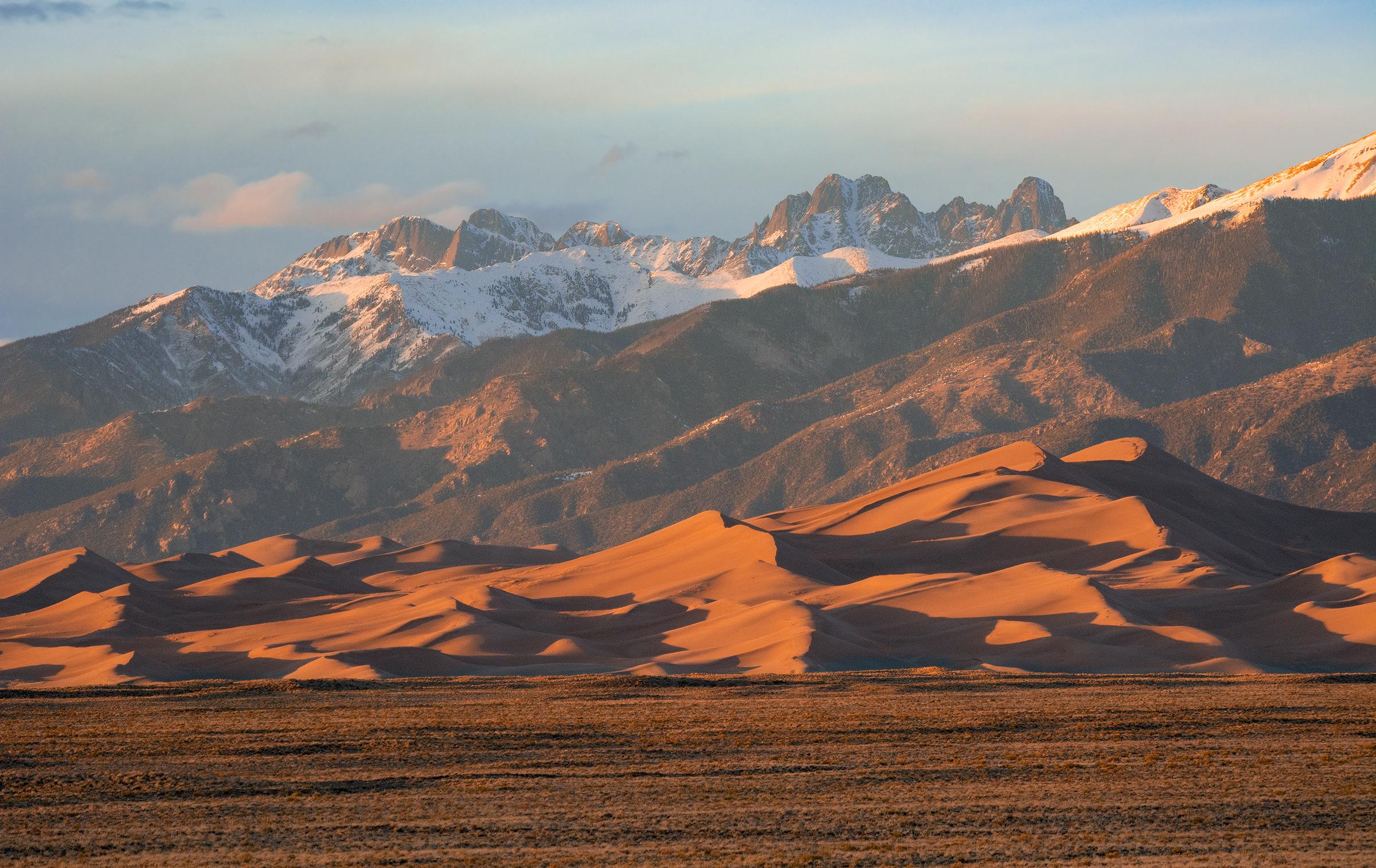
NPS via NPS.gov (Public Domain)
Great Sand Dunes National Park Scenic Drives: Great Sand Dunes
9 min read
Scenic Drives
The Medano Pass Primitive Road is the great sand dunes jeep trail - an 11-mile (one-way) route that runs from the main park area east and north over Medano Pass.
The Drive at a Glance
The Medano Pass Primitive Road is the great sand dunes jeep trail - an 11-mile (one-way) route that runs from the main park area east and north over Medano Pass. This is not a scenic paved loop. It is a proper 4WD road requiring high clearance, low-range gearing, and tires aired down to 18-20 PSI for the soft sand sections.
- Total distance: 22 miles round trip to the pass and back, or 11 miles one-way if you exit via CO 17
- Typical time with stops: 3-4 hours one-way, longer if you explore side trails or hike
- Direction: Drive east from the Dunes Parking Lot area toward Medano Pass. Most visitors go out and back; a through route exits near CO 17 but requires the full 4WD experience
- Road surface: Soft sand in the first section (Castle Creek to Crossing 1), then creek crossings, gravel, and rocky forest road above the pass
- Seasonal opening: Typically June through October, but snow can close the upper pass into July in heavy snow years. Check current conditions at the visitor center before heading out
- Best direction: Eastbound from the dunes side. You get the soft sand early when you're fresh, and the views open up behind you as you climb
The air compressor and tire filling station at the Amphitheater Parking Area is open for the 2026 season. Use it to air down before the drive and air back up after. Rangers will tell you to bring your own portable compressor anyway - the station has been known to have lines on busy weekends, and you don't want to be that person waiting with deflated tires while the afternoon thunderheads build.

Stop by Stop
Castle Creek Crossing
This is where the pavement ends and the real driving begins. Castle Creek runs across the road year-round, typically 6-12 inches deep depending on snowmelt. From this overlook you can see the dunefield rising behind you to the west - a perspective few visitors get.
The road surface here is packed sand and gravel. Take it slow. The water is clear enough that depth perception is tricky; walk it first if you're unsure.
Best time of day: Late morning, after the sun has softened the creek temperature but before afternoon storms develop.
Time to spend: 10-15 minutes to scout the crossing, air down if you haven't already, and take the photo looking back at the dunes.
What most visitors miss: The trail register at the crossing. Sign in. It helps rangers know who's on the road if conditions change.
Soft Sand Section (Castle Creek to Crossing 1)
This 2-mile stretch is where the current NPS alert applies - and where most vehicles get stuck. As of 2026, the sand between Castle Creek and Crossing One is notably soft, and many off-road capable vehicles are becoming stuck here.
Keep your momentum steady. Do not stop on a soft sand section. Do not spin your tires - that just digs you in. If you feel the vehicle bogging down, a slight steering wiggle can help the tires find traction. The great sand dunes jeep trail demands respect here more than anywhere else.
Cell service drops out at Castle Creek and does not return until you're back at the main park road.
Best time of day: Early morning when the sand is cooler and slightly more compacted from overnight moisture. Midday sand temperatures can reach 160°F - not just uncomfortable for walking, but hard on tires.
Time to spend: Drive through without stopping unless you're stuck. If you stop, pick a firm gravel patch.
Crossing One through Crossing Four
The road crosses Medano Creek four more times in the next 3 miles. Each crossing is different - some are wide and shallow, others narrow with a drop at the exit. The creek levels drop as summer progresses; June crossings can be 12-18 inches deep, while August crossings might barely wet your hubs.
Rangers will tell you the golden rule: cross at an angle, not straight across. Enter slow, maintain steady throttle, and don't brake in the water.
From this overlook you can see the dunefield shrinking in your rearview mirror and the forest closing in ahead. The transition from desert sand to pine woodland happens fast here - about 1,000 feet of elevation gain in 4 miles.
Best time of day: Any time the crossings are clear. Later in the day means lower water levels.
Time to spend: About 30-45 minutes to navigate all four crossings if you're experienced. Budget an hour if you're new to this.
Medano Pass (Elevation 10,050 ft)
The summit of the pass is a broad, forested saddle, not a dramatic viewpoint. The reward is what you've just driven through, not what you see from here. To the west, the dunefield is a tan smear on the horizon. To the east, the Sangre de Cristo Mountains roll out toward the Wet Mountain Valley.
This was likely the route Zebulon Pike used in January 1807. Pack extra water for this stretch if you're hiking from here - the trail to Medano Lake starts at the pass and climbs another 1,200 feet.
Best time of day: Midday for the best light on the surrounding peaks. Morning shadows are deep in the forest, and afternoon clouds can roll in by 2 PM.
Time to spend: 15-30 minutes. Eat lunch, check your vehicle, decide whether to continue to the east side or turn back.
What most visitors miss: The short hike up the ridge just north of the pass. It's maybe 10 minutes on an unmarked path and gives you the only clear view in all directions. Worth the scramble.
Optional Extension: Medano Lake Trailhead
If you're continuing east and have the clearance, the Medano Lake Trailhead is 0.5 miles past the pass. Parking is limited to 4-5 vehicles. The trail runs 2.5 miles to a small alpine lake at 11,600 feet, and from there you can continue to the summit of Mount Herard (13,297 feet).
The hiking trails in great sand dunes national park that start from this side of the pass see a fraction of the traffic of the main dunefield trails. If you want solitude, this is it.

Timing and Crowds
The Medano Pass Primitive Road typically opens in late May or June and closes in October or November, depending on snow. The first snow of the season usually closes the upper section by mid-October, though the lower sections near the dunes may remain passable longer.
Crowds on this road are nothing like the main park area. You might see 5-10 vehicles on a summer weekend, fewer on weekdays. The real bottleneck is the soft sand section - one stuck vehicle can block the road for hours. Rangers at the visitor center will tell you the current conditions before you head out. Ask.
Sunrise strategy: Not practical for this drive. The sun rises behind the mountains, so the dunes are backlit until mid-morning. Plus, the sand is coldest right at dawn and the creek crossings are deeper with snowmelt.
Late afternoon strategy: Better light for photography (the dunes catch golden hour from the west), but afternoon thunderstorms build over the mountains in July and August. Be off the pass by 2 PM during monsoon season. Lightning on exposed ridges is a genuine risk.
Those looking for camping near great sand dunes national park should note that the road has several dispersed camping spots along it, but there are no designated sites. Piñon Flats Campground, back in the main area, is the closest developed option, and its sites can be reserved 3 months in advance for 2026.

Driving Logistics
Parking at key stops: The main staging area is the Dunes Parking Lot. Park there, air down, then head east. Do not block the Castle Creek crossing while you air down - pull well off the road.
Vehicle requirements: High clearance 4WD with low range. A stock Jeep Wrangler, Toyota 4Runner, or similar is ideal. Crossovers with "all-wheel drive" and low ground clearance are not recommended. Tires should be aired down to 18-20 PSI for the soft sand; the air compressor at the Amphitheater Parking Area is open for the 2026 season, but bring your own.
What the park website doesn't mention: The soft sand section changes character every time it rains or a vehicle gets stuck. What was firm last week can be axle-deep powder this week. The NPS alert about impassable soft sand between Castle Creek and Crossing 1 is updated regularly - check it before you go.
Gas availability: None in the park. The nearest gas is in Mosca (about 15 minutes southwest on CO 150) or Alamosa (about 30 minutes south). Fill up before you arrive.
Cell service: Drops out at Castle Creek and does not return until you are back at the main park road. Download maps and offline directions before you arrive. The great sand dunes jeep trail has no cell coverage for its entire length.
RV restrictions: The Medano Pass Primitive Road is not suitable for RVs, trailers, or any vehicle over 20 feet. Length and clearance limitations apply at the creek crossings and in the tight forest sections above the pass. The main park road and Dunes Parking Lot can accommodate RVs up to 35 feet.
Sandboarding and sand sledding: Rentals are not available in the park. The NPS alert states that sand board and sled rentals are located in local communities surrounding the park - arrange rentals before you come. Do not expect to rent equipment at the park.

Practical Takeaways
- Air down before the soft sand. Use the Amphitheater Parking Area compressor (open for 2026 season) or bring your own. 18-20 PSI is the sweet spot. Air back up before hitting pavement on the return.
- The soft sand section between Castle Creek and Crossing 1 is the most dangerous part of the drive. Current conditions as of 2026 have vehicles getting stuck here regularly. Do not stop. Do not spin tires. Maintain steady momentum.
- Check the NPS alerts before you go. The alert about impassable soft sand is updated frequently. What was fine yesterday may not be fine today.
- Budget 3-4 hours minimum for the out-and-back from the Dunes Parking Lot to Medano Pass and back. More if you're hiking from the pass.
- Bring your own air compressor. The park's compressor is open, but it's shared. On busy weekends, expect to wait.
- The best camping near great sand dunes national park for this drive is dispersed camping along the road itself - no facilities, no reservations, just find a spot and pack out what you pack in. Piñon Flats Campground is the closest developed option if you want flush toilets and running water.
- The drive is best done eastbound from the dunes side. The views open up behind you, the soft sand is early when you're fresh, and the elevation gain is gradual. Westbound from CO 17 is possible but requires climbing the pass from the east side first, which means creek crossings before you air down.
For a full overview of the park - including fees, hours, and how to plan your trip - see the complete visitor guide. If you're planning to explore on foot from the pass, the hiking trails guide covers the Medano Lake and Mount Herard routes. And for when to catch the best conditions on this road, the best time to visit page breaks down the May-through-October window by month.
For more information, see our complete National Park & Preserve Guide.
Sources
- Official source: NPS — Great Sand Dunes National Park nps.gov/grsa/index.htm
Photo Gallery
More to Explore

Park Guide
Acadia National Park: Carriage Roads, Cadillac Mountain & 2026 Guide
Discover carriage roads, Cadillac Mountain, and rugged Maine coast. Complete 2026 guide to Acadia National Park — trails, fees, lodging, permits, and what rangers recommend.

Hiking Guide
Grand Canyon Hiking Trails: Day Hikes, Water Sources & Rim to Rim
Compare Grand Canyon hiking trails: Bright Angel, South Kaibab, Hermit, Grandview, and rim to rim, with distances, elevation, water stops, and trailhead access for each.

Best Of
Best of Glacier Bay National Park
The best of Glacier Bay is reached by boat: ranger-led day tours up the bay to the tidewater glaciers. What's worth it, how to book, and when to go (2026).

Campsite Guide
White Sands Backcountry Camping: Closed for 2026 — What to Know
As of 2026, backcountry camping at White Sands National Park is closed for site rehabilitation. What that means, and where to camp nearby instead.

Weather Guide
Guadalupe Mountains National Park Weather: Weather
Guadalupe Mountains National Park: weather guide guide updated 2026. Practical visitor information, reservations, and seasonal tips worth bookmarking before

Best Of
Best of Cuyahoga Valley National Park: Best Things to Do
Seeing a Cleveland Orchestra concert with the woods as your backdrop is a uniquely Cuyahoga Valley experience.
Sign in to join the conversation.
Sources & Attribution
Location data courtesy of the National Park Service (U.S. Department of the Interior). NPS data is public domain. Official NPS page.
Images: NPS; NPS; NPS; NPS; NPS.
Map data © OpenStreetMap contributors.
Park operations alerts: NPS.gov · Weather and weather hazards: National Weather Service · Live conditions.
Information may change. Always verify fees, hours, and conditions directly with the official source before visiting.
Did this guide help? Share it with a friend.