The CCC Technical Building at milepost 51.7 near Big Meadows is a tangible link to the Civilian Conservation Corps' work that shaped Shenandoah's landscape. Visit before 7 AM to secure parking at Old Rag, then explore this historic site—entrance fees are cashless as of 2025.
NPS via NPS.gov (Public Domain)
CCC Technical Building
10 min read
Places & Points of Interest
Discover CCC Technical Building: ccc technical building with our comprehensive guide. Expert tips, practical information, and insider knowledge.
Your plans
Overview
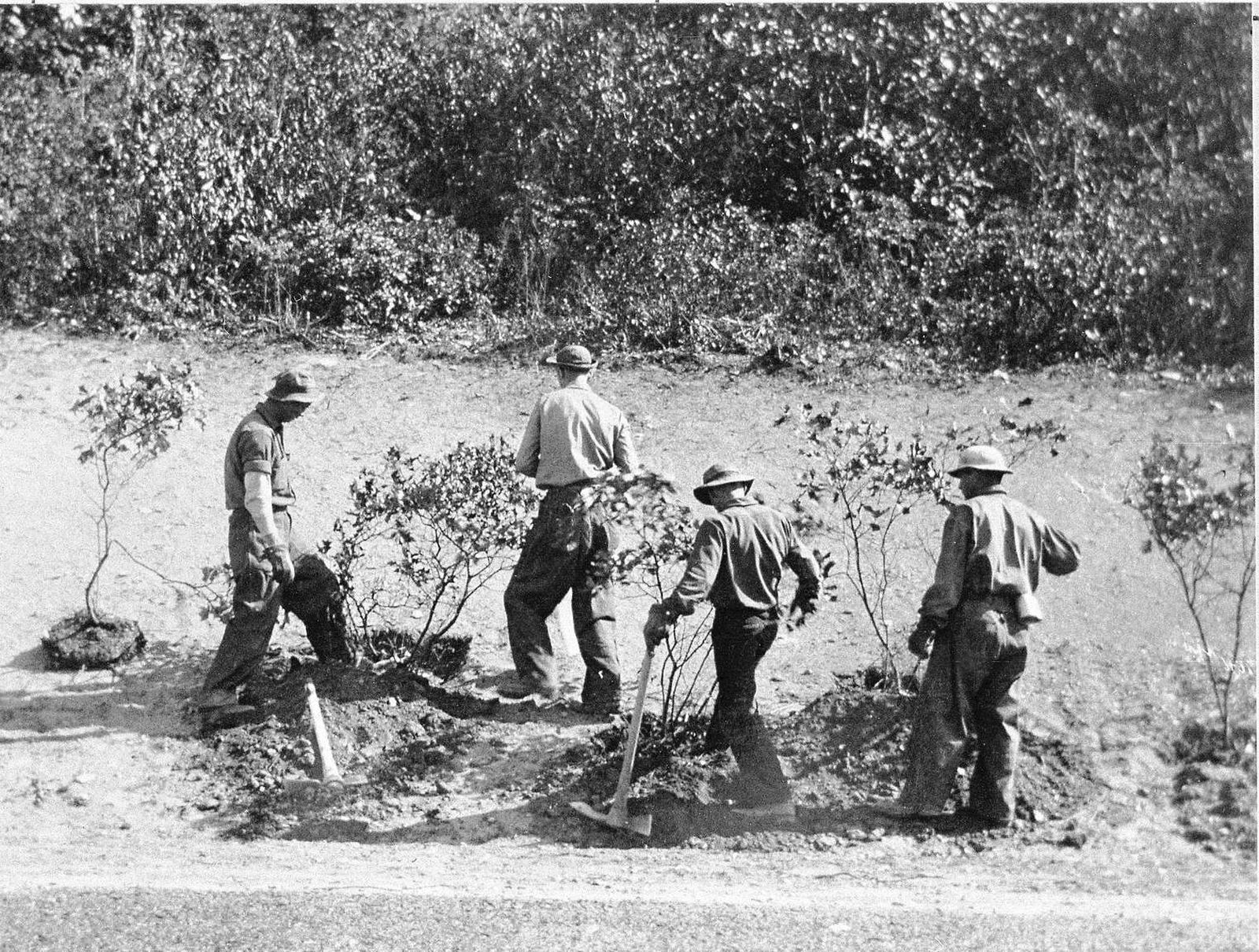
The CCC Technical Building, at milepost 51.7 near Big Meadows, stands as a quiet testament to the hands that shaped this park. While the Civilian Conservation Corps didn't engineer Skyline Drive—that task fell to the Bureau of Public Roads—they constructed the overlooks, planted countless trees and mountain laurel to restore scarred hillsides, and crafted the landscape that frames every vista. This building was part of the camp where those young men lived and worked. It serves as a tangible reminder that Shenandoah was made, not merely discovered. You'll encounter dozens of their projects unnoticed; each stone wall and overlook originated here.
Shenandoah National Park spans 105 miles of the Blue Ridge Mountains in Virginia, encompassing nearly 200,000 acres of protected forest. Skyline Drive traces its length, while the Appalachian Trail follows its spine. Elevations vary from roughly 550 feet to 4,051 feet at Hawksbill Summit. Up here, the air carries distinct scents—pine resin, damp soil, and in summer, the sweetness of mountain laurel. Sounds include the steady rustle of leaves, broken by a raven's call or the distant tap of trekking poles. New visitors often underestimate the weather shifts; a sunny valley can lie beneath a cool, damp cloud at a 3,000-foot overlook.
Quick Information
- Entrance Fee: As of 2026, the park entrance fee is $30 per private vehicle, $25 per motorcycle, or $15 per person entering on foot or bicycle. The pass is valid for 7 consecutive days. The park transitioned to a fully cashless system in July 2025; only credit cards, debit cards, or mobile payments are accepted at entrance stations.
- Hours: Shenandoah National Park and Skyline Drive are open 24 hours a day, year-round. However, sections of Skyline Drive close during inclement winter weather (typically ice and snow). The park's visitor centers, lodges, and waysides have seasonal operating hours.
- Best Time to Visit: Late May through June for wildflowers and mild temperatures, or October for fall foliage. September and early November often see fewer crowds.
- Location: Virginia. Nearest major access points are Front Royal (north entrance), Thornton Gap (central), and Swift Run Gap (south). The GPS coordinates for the CCC Technical Building are 38.516675, -78.431289.
- Accessibility: Skyline Drive itself is fully accessible. Many overlooks have paved paths to viewing areas. The Limberlost Trail is a 1.3-mile crushed greenstone loop that is fully accessible. Visitor centers and some picnic grounds have accessible facilities. Always check current conditions, as steep terrain and weather can impact access.
- Cell Service: Cell service is notoriously spotty and drops out frequently along Skyline Drive. Do not rely on it for navigation or emergency communication. Rangers recommend downloading maps and information ahead of time.
- Restrooms: Available at all major visitor centers (Dickey Ridge, Byrd, Loft Mountain), waysides (Elkwallow, Big Meadows, Loft Mountain), and picnic grounds. These are modern restrooms. Vault toilets are available at some trailheads and smaller picnic areas.
- Parking: Parking is the primary constraint on busy days. The lots for popular trails like Dark Hollow Falls, Old Rag (boundary lot), and Stony Man fill by 9 AM on weekends and by 10 AM on weekdays during peak season. Overflow parking along Skyline Drive is prohibited and will get your vehicle towed.

Getting There
The most common approach is from the north via Interstate 66 and U.S. 340 to Front Royal, where you'll find the Dickey Ridge Visitor Center and the north entrance station at milepost 0. From Washington D.C., this is about a 70-mile drive, taking roughly 1.5 hours without traffic. From the south, the Rockfish Gap entrance near Waynesboro (milepost 105) connects to Interstate 64. The central Thornton Gap entrance (milepost 31.5) is accessed via U.S. 211 from Luray.
Your strategy depends on your goal. For the central district and the CCC Technical Building near Big Meadows, use the Thornton Gap entrance. For the popular Old Rag hike, you must use a boundary parking area outside the park and will need a separate day-use ticket from March 1 through November 30. The park's single gas station is at Big Meadows Wayside (mile 51.2). It's the only one on Skyline Drive, so fill up before you enter. The pumps were closed for upgrades as of early 2026, so verify status before counting on it.
What to Expect
Expect a park defined by its ridge. You'll spend most of your time between 2,000 and 3,500 feet in elevation, driving or hiking along the crest of the Blue Ridge. The terrain on either side is dramatically different: to the west, the land drops steeply into the Shenandoah Valley, with farms and towns visible on clear days; to the east, it rolls more gently into the Virginia Piedmont. The forest is predominantly oak and hickory, with stands of pine and, at higher elevations, spruce. It's a green tunnel for much of the drive, broken suddenly by a stone-framed overlook that opens to a view stretching 50 miles.
First-time visitors commonly underestimate two things: the traffic and the microclimates. On a fall weekend, Skyline Drive can move at a crawl, with cars backed up at every popular overlook. And the temperature at Hawksbill Gap can be 15 degrees cooler with a stiff wind, while it's shirtsleeve weather at the valley floor. You'll feel the altitude on the hikes - what's listed as "moderate" often includes sustained, leg-burning climbs. The trail surfaces vary from packed dirt and gravel to exposed sandstone slabs and, in places, a jumble of boulders you'll need your hands for.

Top Attractions & Points of Interest
Big Meadows
At mile 51, this high-elevation meadow is a surprise after miles of dense forest. It's a prime spot for wildlife viewing at dawn and dusk - white-tailed deer are almost guaranteed, and you might spot a grazing black bear at the tree line. The meadow is also a hub, with the lodge, wayside, campground, and picnic grounds all clustered nearby. The CCC Technical Building is just half a mile south. Walk the edges of the meadow on the Story of the Forest Trail, but stay on the path to protect the fragile ecosystem.
Hawksbill Summit
The highest point in the park at 4,051 feet. There are three routes up: the shortest and steepest from Hawksbill Gap (mile 45.5), a longer loop from the same lot, and the most gradual from the Upper Hawksbill parking area (mile 46.5). The summit has a stone viewing platform with 360-degree views. On a clear day, you can see the Shenandoah Valley to the west and the Piedmont to the east. The platform is often windy, even on calm days below.
Old Rag Mountain
The park's most famous and demanding hike, requiring a day-use ticket for peak season. The 9-mile circuit involves a strenuous rock scramble that demands full use of your hands. It's not a hike - it's a climb in places. The parking situation is critical: you must park at the boundary lot and shuttle or walk an additional mile to the trailhead. Rangers will tell you that most rescues here are due to fatigue, dehydration, or attempting the scramble in poor weather. Start early.
Dark Hollow Falls
One of the most accessible and popular waterfalls, located near Big Meadows at mile 50.7. It's a 1.4-mile round trip, but don't be fooled - the hike back is almost entirely uphill. The 70-foot cascading waterfall is best in spring or after heavy rains. The trail is often crowded and can be slippery with wet leaves and mud. Pets are not allowed on this trail.
Stony Man
At mile 41.7, this is perhaps the best reward-for-effort hike in the park. A 1.6-mile round trip on a relatively gentle trail leads to the second-highest peak, with a panoramic view of the Shenandoah Valley. It's an excellent sunrise or sunset spot. The trailhead shares a lot with the Skyland Resort, which can make parking tricky during meal times.
Rapidan Camp
The restored retreat of President Herbert Hoover, accessible by a 4-mile round trip hike from the Milam Gap parking area (mile 52.8). It's a journey into both political and natural history. The camp sits at the confluence of two streams and feels removed from time. Rangers sometimes lead guided tours here; check the schedule at the Byrd Visitor Center.
Blackrock Summit
An easy, 1-mile loop from the Trayfoot Mountain parking area (mile 84.8) that feels like another world. The trail leads across a massive slope of quartzite boulders (talus) with wide-open views of the valley. It's fantastic for sunset and is less crowded than many central park attractions. The rocks can be unstable, so watch your footing.
The Overlooks
Skyline Drive has 75 overlooks. Some are forgettable, a few are essential. Baldface Mountain Overlook (mile 62.8) offers one of the highest vantage points at 3,345 feet. Browntown Valley Overlook (mile 71.2) frames a historic valley community. Spitler Knoll Overlook (mile 48) is a quiet spot often missed by the crowds rushing to Big Meadows. The rule of thumb: if the parking lot is packed, the next one a few miles down the road will likely be half empty with a similar view.
Activities
Hiking
With over 500 miles of trails, hiking is the core activity. They range from easy, paved walks like the Limberlost Trail to epic, all-day circuits like the Riprap-Wildcat Ridge loop. The Appalachian Trail runs 101 miles through the park, accessible from numerous crossings. For waterfall seekers, Rose River Falls and Doyles River Falls make a excellent combined loop. The park's wilderness areas, like the Shenandoah Wilderness, offer more solitude. Always check the trailhead register for recent notes from other hikers.
Wildlife Viewing
White-tailed deer are ubiquitous. Black bears are common but secretive; you're most likely to see one at dawn or dusk in the Big Meadows area. Wild turkeys, red-tailed hawks, and pileated woodbirds are frequently seen. The park is a birdwatcher's paradise. Remember to keep a safe distance from all wildlife - especially bears. Use binoculars or a long lens.
Stargazing
The park has designated dark sky areas, with Big Meadows being a prime spot. The lack of light pollution on the mountain ridge makes for exceptionally clear skies on cloudless nights. The Milky Way is often visible to the naked eye. Rangers offer occasional night sky programs at the Big Meadows amphitheater.
Scenic Driving
Skyline Drive is the activity for many visitors. The 105-mile road has a 35 mph speed limit, which feels appropriate given the curves and the views. Plan for at least 3 hours to drive the full length without stops. In fall, weekend traffic can double that time. Motorcyclists frequent the drive, but be aware of wet leaves, gravel, and deer on the roadway.
Photography
The golden hours after sunrise and before sunset provide the best light, cutting through the haze that often settles in the valleys. Fog in the hollows at dawn can create scenes. Classic shots include the view from Marys Rock, the cascades of Whiteoak Canyon, and the historic structures like the CCC Technical Building. A polarizing filter helps cut glare from the leafy canopy.
For more detailed route descriptions and trail maps, see our guide to the best hiking trails in Shenandoah.

Seasonal Guide
March - May: The park reawakens. Service facilities like Big Meadows Wayside typically reopen in late March. Early spring can be muddy and chilly, with occasional snow at higher elevations. By late April and May, wildflowers bloom and the trees leaf out. Crowds are manageable until Memorial Day.
June - August: Full summer operations. All campgrounds and lodges are open. Temperatures are pleasant on the ridge (70s-80s F) but can be hot and humid in the valleys. Afternoon thunderstorms are common and can be severe. This is the busiest season. Bugs, especially ticks and mosquitoes, are present.
September - October: The most popular season due to fall foliage. Crowds peak in mid-October. The weather is ideal for hiking - cool, crisp air. By November, most leaves have fallen, crowds dissipate, and facilities begin to close for the season. The Big Meadows Wayside typically closes in mid-November.
December - February: A quiet, starkly beautiful time. Skyline Drive may close for days at a time following snow and ice storms. Sections remain open for cross-country skiing and snowshoeing when conditions allow. The only open campground is typically Mathews Arm, and only for winter camping. Always check the road status before visiting.
For a more detailed breakdown of weather patterns and crowd calendars, consult our dedicated guide on the best time to visit.
Practical Information
Fees & Passes: The $30 vehicle pass is your best value. America the Beautiful Annual Pass ($80) covers entrance fees for the passholder and accompanying passengers. Seniors can purchase a lifetime pass for $80. The park is cashless.
Permits: Backcountry camping requires a free permit, available at visitor centers or self-registration stations. The Old Rag day-use ticket is required from March 1 through November 30 and must be obtained online in advance. They often sell out.
Camping: The park has four major campgrounds. Big Meadows (mile 51.2, 221 sites, $75/night) is central and often full. Lewis Mountain (mile 57.5, 30 sites, $30/night) is first-come, first-served. Loft Mountain (mile 79.5, 219 sites, $30/night) is the largest. Mathews Arm (mile 22.1, 165 sites, $30/night) is the northernmost. All have restrooms with cold running water and pay showers nearby (except Mathews Arm). Sites can be reserved at recreation.gov.
Lodging: In-park lodging includes Big Meadows Lodge (
For more information, see our complete Shenandoah National Park Guide.
Sources
- Official source: NPS — Shenandoah National Park nps.gov/shen/index.htm
- Official source: National Park Service nps.gov/places/000/ccc-technical-building.htm
Photo Gallery
More to Explore

Park Guide
Acadia National Park: Carriage Roads, Cadillac Mountain & 2026 Guide
Discover carriage roads, Cadillac Mountain, and rugged Maine coast. Complete 2026 guide to Acadia National Park — trails, fees, lodging, permits, and what rangers recommend.

Hiking Guide
Grand Canyon Hiking Trails: Day Hikes, Water Sources & Rim to Rim
Compare Grand Canyon hiking trails: Bright Angel, South Kaibab, Hermit, Grandview, and rim to rim, with distances, elevation, water stops, and trailhead access for each.

Best Of
Best of Glacier Bay National Park
The best of Glacier Bay is reached by boat: ranger-led day tours up the bay to the tidewater glaciers. What's worth it, how to book, and when to go (2026).

Campsite Guide
White Sands Backcountry Camping: Closed for 2026 — What to Know
As of 2026, backcountry camping at White Sands National Park is closed for site rehabilitation. What that means, and where to camp nearby instead.

Weather Guide
Guadalupe Mountains National Park Weather: Weather
Guadalupe Mountains National Park: weather guide guide updated 2026. Practical visitor information, reservations, and seasonal tips worth bookmarking before

Best Of
Best of Cuyahoga Valley National Park: Best Things to Do
Seeing a Cleveland Orchestra concert with the woods as your backdrop is a uniquely Cuyahoga Valley experience.
Sign in to join the conversation.
Sources & Attribution
Location data courtesy of the National Park Service (U.S. Department of the Interior). NPS data is public domain. Official NPS page.
Images: NPS; NPS; NPS; NPS; NPS.
Map data © OpenStreetMap contributors.
Park operations alerts: NPS.gov · Weather and weather hazards: National Weather Service · Live conditions.
Information may change. Always verify fees, hours, and conditions directly with the official source before visiting.
Did this guide help? Share it with a friend.