Big Bend National Park Weather: Weather (2026 Guide)
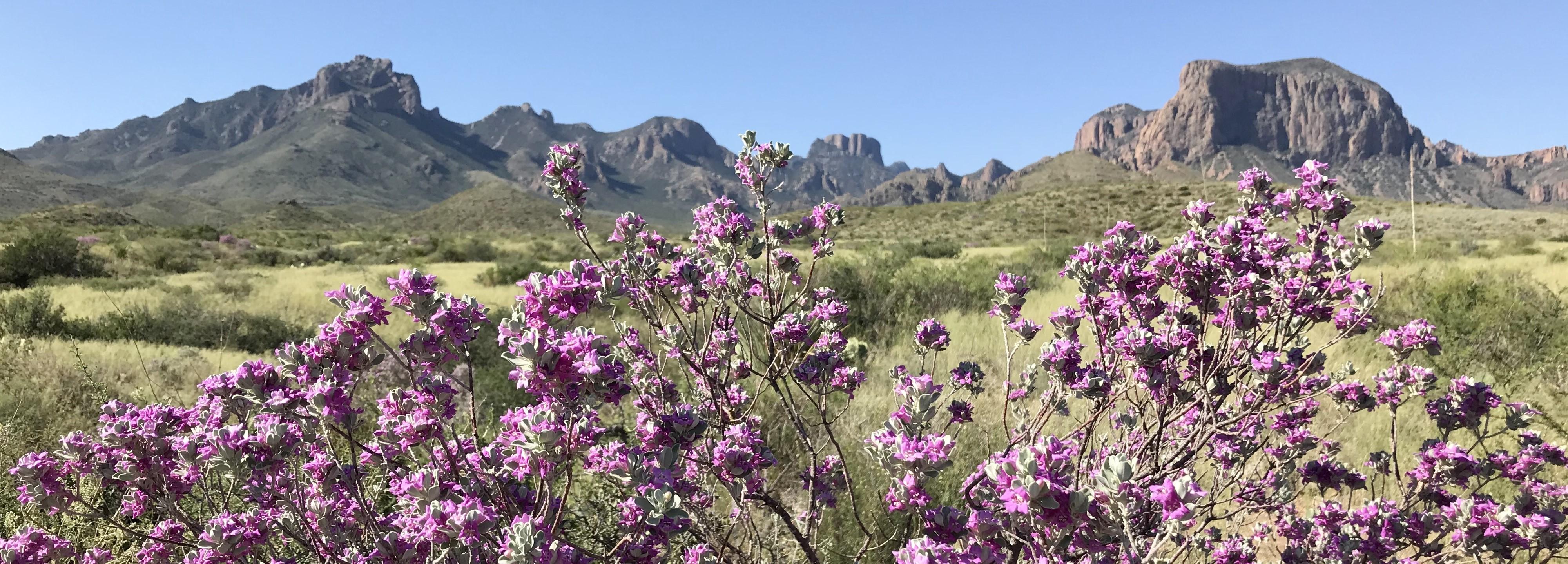
NPS via NPS.gov (Public Domain)
Big Bend National Park Weather
10 min read
Weather Guide
Big Bend weather splits by elevation - a 15-20F difference between the desert floor and the Chisos Mountains. Plan hikes by altitude (2026).
The single most important thing to understand about Big Bend National Park weather is the vertical split. The park isn't one climate; it's two stacked on top of each other. The desert floor, where the Rio Grande flows, operates on a different planet than the Chisos Mountains rising nearly a mile above it. A forecast for "Big Bend" is useless. You need to know which Big Bend you'll be in. Most first-time visitors are caught off guard by the intensity of the sun at 2,000 feet and the genuine chill that can settle into the high basins at 6,000 feet on the same day. The park's weather reality is defined by this altitude-driven schism, a relentless desert sun, and distances so vast that a storm on one horizon can be a dry, blue sky where you're standing.
The Weather Reality
Big Bend sits in the heart of the Chihuahuan Desert, a rain shadow locked between mountain ranges. Sunshine isn't just common; it's the default setting for over 300 days a year. What defines the experience here isn't precipitation - it's solar intensity and radical temperature swings driven by elevation. The official forecast for the region will almost never capture the 15- to 20-degree Fahrenheit difference between the river and the mountain peaks, a gap that feels like traveling from Phoenix to Denver in a 30-minute drive.
The desert floor acts as a solar oven. From late spring through early fall, it doesn't just get hot; it stores heat in the rock and soil, releasing it long after sunset. This makes overnight lows surprisingly mild in the lowlands during summer, but it also means the heat builds quickly from the moment the sun crests the horizon. Conversely, the Chisos Mountains create their own microclimate. They catch the scant moisture that makes it this far inland, leading to slightly more cloud cover and the park's rare but dramatic summer thunderstorms. The air up there is thinner, the sun still fierce, but the ambient temperature is human-compatible for most of the year. Rangers will tell you that planning your day around altitude is the most critical skill for visiting Big Bend. Hiking the desert in the morning and retreating to the mountains for the afternoon isn't a luxury; it's a standard survival strategy for half the year.

Month by Month
Big Bend's visitation and conditions pivot sharply with the thermometer. Crowds follow comfort, which creates a very clear seasonal rhythm.
November - February (The Pleasant Season)
* Temperatures: Desert highs 60-70°F, lows 35-45°F. Chisos highs 50-60°F, lows 30-40°F. Freezing nights are common, especially in the mountains.
* Precipitation: Minimal. The driest time of year. Snow is rare but not unheard of in the Chisos Basin; it typically melts by midday.
* What's Open: All paved roads and primary facilities are open. Some concession services (like the river outfitter) may operate on reduced hours. The Boquillas Crossing Port of Entry often shifts to winter hours; as of 2026, it was operating Friday-Monday, 9 AM to 4 PM.
* Crowd Level: Moderate to High. This is the second busiest season after spring. Thanksgiving, Christmas, and February weekends see the most visitors. Campgrounds fill.
* Wildlife: Excellent for birding as migratory species are present. Mule deer and javelina are more active during the comfortable daytime hours.
* Trail Conditions: Ideal for hiking anywhere in the park. Desert trails are perfect. The cold, dry air makes strenuous mountain hikes like the South Rim feel brisk and invigorating.
* Worth Considering: The most reliable window for extensive, full-day hiking without heat stress. Clear, cool nights are superb for stargazing.
* Challenging Aspects: Short daylight hours. You'll need serious cold-weather gear for camping, especially in the mountains where temperatures can dip into the 20s. The water in your bottle will freeze overnight.
March - April (The Peak Season)
* Temperatures: Desert highs 80-90°F, lows 50-60°F. Chisos highs 70-80°F, lows 45-55°F.
* Precipitation: Very low, but wind increases significantly. Spring winds can be persistent and strong, making canyon hikes noisy and dusty.
* What's Open: Everything is fully operational.
* Crowd Level: High to Very High. This is the park's busiest time. Every campground, lodge room, and popular trailhead parking lot will be full by mid-morning. Reservations are mandatory.
* Wildlife: Peak wildflower season in the desert (March-April) and later in the mountains (April-May). Prime time for seeing blooming cacti.
* Trail Conditions: Generally excellent, but the desert starts to warm up by late April. The window for comfortable low-elevation hiking closes rapidly.
* Worth Considering: The best balance of warm days, cool nights, and long daylight hours. If you can handle the crowds, the weather is nearly perfect.
* Challenging Aspects: The crowds are real. You will need a plan for everything. The wind can be a relentless companion, grating on nerves after a few days.
May - September (The Hot Season)
* Temperatures: Desert highs 100-105°F+, lows 75-80°F. Chisos highs 85-95°F, lows 60-70°F. The key is "by late morning" - the desert floor often hits 100°F before 11 AM.
* Precipitation: The North American Monsoon brings sporadic, violent thunderstorms from July through September. These are localized, dramatic events that can cause flash flooding in canyons and drainages. Humidity rises noticeably after rains.
* What's Open: Most facilities remain open, but some ranger programs may be limited. Always check if dirt roads like Black Gap Road are open; as of 2026, it was closed due to prior flood damage.
* Crowd Level: Low. The heat acts as a powerful crowd filter. You'll have vast stretches of the park to yourself, but so will the sun.
* Wildlife: Reptiles are most active. Birding is slower. The desert comes alive briefly after monsoon rains.
* Trail Conditions: Hiking in the desert is not just unpleasant; it's dangerous and discouraged. Mountain trails are hikeable very early in the morning. Flash flood risk is serious in all canyons (Santa Elena, Boquillas, Mariscal) during storms.
* Worth Considering: Solitude. Spectacular lightning shows over the desert. The river may be more inviting for a quick, cautious cool-off (currents are always a factor).
* Challenging Aspects: The heat is a physical threat. Hiking is restricted to high-elevation trails at dawn. Your vehicle's air conditioning becomes a life-support system. Planning revolves entirely around avoiding the sun.
October (The Transition)
* Temperatures: Desert highs 85-90°F, lows 55-65°F. Chisos highs 75-80°F, lows 50-55°F.
* Precipitation: Low. The monsoon tapers off. Weather is generally stable and dry.
* Crowd Level: Low to Moderate. A sweet spot between the crushing spring crowds and the onset of winter visitors.
* Trail Conditions: Desert trails become hikeable again, especially in the morning. Mountain trails are ideal.
* Worth Considering: Perhaps the best single month for balanced visitation. Warm days, cool nights, fewer people, and open trails.
* Challenging Aspects: Unpredictable. An early heatwave or an early cold snap can happen. It's a roll of the dice, but the odds are good.

Best Times for Specific Activities
Your ideal month depends entirely on what you want to do.
* Hiking the High Country (Chisos Mountains): October through April. This is when you can tackle the South Rim or Emory Peak without pre-dawn alarms or heat exhaustion. February and March offer the longest, most stable days.
* Hiking the Desert and River Canyons: November through March. This is your only safe window for extended hikes like the Outer Mountain Loop or exploring lower canyons. By April, the desert sun is already gaining its edge.
* Wildlife & Bird Viewing: Spring (March-May) for peak diversity and activity, especially for birds. Winter (Nov-Feb) for seeing larger mammals like deer and mountain lions more active in daylight.
* Wildflower Blooms: March-April in the desert for cactus and annuals. April-May in the Chisos for higher-elevation flowers.
* Stargazing: Any clear night. But the best combination of comfortable temperatures and dark skies is Fall and Winter (Oct-Feb). The air is often drier and more stable, providing sharper views of the legendary dark skies.
* River Activities (Canoeing/Kayaking): Late Fall through Early Spring (Nov-Apr). Water levels are more predictable, and air temperatures make being on the water pleasant. Summer river trips are a serious undertaking due to heat and volatile thunderstorm potential.

What to Pack by Season
Forget generic lists. Pack for the altitude you'll be in.
Winter (Nov-Feb):
* Desert: Layers. A warm fleece or puffy jacket for mornings/evenings, a sun shirt or light long-sleeve for day. Sturdy pants. A beanie for cold dawns.
* Mountains: Serious insulation. A down jacket, thermal base layers, gloves, and a warm hat are non-negotiable for camping or early hikes. Your summer sleeping bag won't cut it.
* Both: Windproof layer. The desert can be bitterly windy. Lip balm and heavy lotion - the dry air chaps skin instantly.
Spring (Mar-Apr):
* Everything: Windbreaker or light shell. A bandana or Buff for dust. Wide-brimmed hat with a chin strap (the wind will take it). Sunglasses. All your sun protection - the UV index is high even when the air feels cool.
* Footwear: Broken-in hiking boots with good traction. Trail runners for well-maintained paths. The terrain is rough and rocky.
Summer (May-Sep):
* The Rule: If you're hiking, you should be done by 10 AM. Your packing reflects this.
* Clothing: Light-colored, moisture-wicking, long-sleeved shirts and pants for sun protection. A wide-brimmed hat is a medical device.
* Hydration: Not just a water bottle. A hydration reservoir (3L minimum) plus extra water in the car. Electrolyte tablets or powder. You will drink more than you think is possible.
* Vehicle: Sunshades for the windshield. A cooler with extra water and wet towels. Check your tire pressure and coolant before entering the park.
Fall (Oct):
* A mix of spring and winter gear. Be prepared for warm days and surprisingly chilly nights. Layers are everything.

What the Forecast Doesn't Tell You
- The Sun is a Physical Force: The UV radiation at this latitude and elevation will burn you through a car window. Sunscreen, reapplied hourly, is mandatory. A wide-brimmed hat isn't optional attire; it's essential gear.
- Flash Floods Don't Need Local Rain: A thunderstorm 20 miles upstream in the watershed can send a wall of water through Santa Elena Canyon while you're under blue skies. Never enter a canyon if storms are forecast anywhere in the region. Check the hiking trails guide for specific canyon risks.
- Your Car is Part of Your Kit: Distances are vast. A breakdown without adequate water is an emergency. There is no cell service on most park roads. Fill your gas tank in Marathon or Study Butte. If you have an electric vehicle, note: there are no charging stations in the park. The closest is 130 miles away in Fort Stockton.
- "Cooler in the Mountains" is Relative: A 95°F day in the Chisos is still hot, especially on exposed, shadeless switchbacks. It's more manageable, but it still demands respect, early starts, and lots of water.
- Wind is a Season: Spring wind can last for weeks, not days. It whips dust, makes conversation on ridges impossible, and can be genuinely exhausting. Pack patience and that chin strap for your hat.
- Temperature Drops Fast at Dusk: The lack of humidity means the day's heat vanishes the moment the sun dips below the horizon. You'll go from comfortable to reaching for a jacket in minutes. Pack it before you head out for sunset.
- Microclimates in Canyons: Deep canyons like Santa Elena can be 10-15 degrees cooler than the nearby desert trailhead. They can also trap cold air, making them feel refrigerator-like on a winter morning. Layer accordingly.
Practical Takeaways
- Plan by Altitude: Schedule desert activities for winter and early morning. Use the Chisos Mountains for hiking during the hotter months. Your daily itinerary should migrate vertically with the sun.
- The Crowd/Comfort Trade-Off is Real: Perfect weather (Mar-Apr) brings everyone. Solitude (Jun-Sep) requires enduring extreme heat. The shoulder months (Oct, Nov, Feb) often offer the best compromise.
- Water Calculations are Serious: Plan for one gallon of water per person, per day, just for drinking. Double that if you're doing any summer hiking. You cannot over-hydrate here.
- Check Road Conditions Daily: Dirt roads like River Road or Old Maverick can become impassable with any rain. Stop at Panther Junction Visitor Center for the latest. As of 2026, Black Gap Road was closed due to flood damage.
- Your Footwear Matters More Than Your Jacket: The terrain is unforgiving - sharp limestone, loose gravel, and uneven rock. Quality, broken-in hiking boots will do more for your enjoyment than any other piece of gear.
- Book Everything Early: For the comfortable seasons, secure your camping options or lodge reservations the moment they become available (often 6 months in advance). First-come, first-served is a high-stakes gamble from November through April.
- Respect the Heat's Timeline: In summer, if you aren't on the trail by 6 AM, you're too late. Your hiking day is over by late morning. Use the afternoons for scenic drives, the visitor center, or napping in the shade.
Big Bend doesn't cater to casual preparation. Its weather demands that you pay attention, plan specifically, and pack with intention. Do that, and you'll be rewarded with some of the most profound quiet and stark beauty the American Southwest has to offer. For more on navigating the park beyond the climate, our complete visitor guide has the details.
For more information, see our complete National Park Guide.
Related: big bend national park guide
Related: big bend national park lodges guide
Sources
- Official source: NPS — Big Bend National Park nps.gov/bibe/index.htm
Photo Gallery
More to Explore

Park Guide
Acadia National Park: Carriage Roads, Cadillac Mountain & 2026 Guide
Discover carriage roads, Cadillac Mountain, and rugged Maine coast. Complete 2026 guide to Acadia National Park — trails, fees, lodging, permits, and what rangers recommend.

Hiking Guide
Grand Canyon Hiking Trails: Day Hikes, Water Sources & Rim to Rim
Compare Grand Canyon hiking trails: Bright Angel, South Kaibab, Hermit, Grandview, and rim to rim, with distances, elevation, water stops, and trailhead access for each.

Best Of
Best of Glacier Bay National Park
The best of Glacier Bay is reached by boat: ranger-led day tours up the bay to the tidewater glaciers. What's worth it, how to book, and when to go (2026).

Campsite Guide
White Sands Backcountry Camping: Closed for 2026 — What to Know
As of 2026, backcountry camping at White Sands National Park is closed for site rehabilitation. What that means, and where to camp nearby instead.

Weather Guide
Guadalupe Mountains National Park Weather: Weather
Guadalupe Mountains National Park: weather guide guide updated 2026. Practical visitor information, reservations, and seasonal tips worth bookmarking before

Best Of
Best of Cuyahoga Valley National Park: Best Things to Do
Seeing a Cleveland Orchestra concert with the woods as your backdrop is a uniquely Cuyahoga Valley experience.
Sign in to join the conversation.
Sources & Attribution
Location data courtesy of the National Park Service (U.S. Department of the Interior). NPS data is public domain. Official NPS page.
Images: NPS; NPS; NPS; NPS; NPS.
Map data © OpenStreetMap contributors.
Park operations alerts: NPS.gov · Weather and weather hazards: National Weather Service · Live conditions.
Information may change. Always verify fees, hours, and conditions directly with the official source before visiting.
Did this guide help? Share it with a friend.