Grand Teton National Park was established in 1929, its name taken from the French les trois tétons for the three prominent peaks that dominate the skyline. The park's 310,000 acres protect a vertical landscape where elevation changes everything, creating a patchwork of habitats from sagebrush flats to alpine tundra. This guide focuses on the practical realities of navigating that terrain in 2026, where construction is planned and knowing which parking lot fills first matters more than any brochure description.
NPS via NPS.gov (Public Domain)
A Patchwork of Habitats
10 min read
Places & Points of Interest
Discover A Patchwork of Habitats: a patchwork of habitats with our comprehensive guide. Expert tips, practical information, and insider knowledge.
Your plans
Quick Information
The entrance fee is $35 per vehicle, valid for seven days. An annual park pass costs $70. The America the Beautiful Interagency Annual Pass ($80) covers entry. As of 2026, parkwide construction is planned; Colter Bay is anticipated to be a good option for visitors seeking fewer disruptions.
Park roads and facilities are generally open from late May through October. The Moose, Jenny Lake, and Colter Bay Visitor Centers operate daily in summer. The best time to visit for reliable access and weather is July through September. Cell service is unreliable beyond developed areas; expect no signal on most trails. Restrooms are available at all visitor centers, major trailheads, and campgrounds. Parking is the primary daily challenge - lots at popular trailheads like Jenny Lake and String Lake fill by 8 AM on summer mornings.
Getting There
The park is in northwestern Wyoming. Jackson Hole Airport (JAC) is the only commercial airport within a national park, located just north of the town of Jackson. From the airport, it's a 15-minute drive north on US-191 to the Moose Entrance Station. Driving from Salt Lake City takes about 5 hours via I-80 and US-89. From the south, take US-191/26/89 from Jackson. From the north, the park connects to Yellowstone via the John D. Rockefeller, Jr. Memorial Parkway.
There are three main entrances: Moose (south), Moran (east), and Granite Canyon (southwest, via Teton Village). For most visitors heading to Jenny Lake or the valley floor, the Moose entrance is the most direct. The Moose-Wilson Road provides a scenic, winding connection between Moose and Teton Village, but check for seasonal closures - it's often closed to vehicles in winter and can be rough.

What to Expect
You are entering a place defined by vertical relief. The valley floor sits around 6,800 feet; the summit of the Grand Teton is 13,775 feet. That 7,000-foot difference happens over just a few horizontal miles, creating the park's defining a patchwork of habitats. In one glance from the valley, your eyes cross sagebrush steppe, riparian corridors, conifer forests, and sheer rock.
The air is dry. Sunburn happens fast. Afternoon thunderstorms are a near-daily event in July and August, building over the peaks by noon and sometimes bringing lightning and sudden temperature drops. The wind has a presence here, funneling through canyons and across Jackson Lake. The soundscape shifts from the buzz of insects in the meadows to the crunch of glacial till underfoot to the absolute silence of a high alpine basin.
Most first-time visitors are caught off guard by two things: the sheer scale, which makes distances deceptive, and the density of traffic around Jenny Lake between 9 AM and 4 PM. The common mistake is trying to do too much in one day. Rangers will tell you to pick one major activity and savor it.
Top Attractions & Points of Interest
Oxbow Bend
This sweeping bend in the Snake River is the park's most famous reflection spot. Mount Moran is perfectly framed in the still water at sunrise. You pull off the main highway (US-89/191/287) into a large turnout. Early morning is your best bet for calm water and fewer people. It's also a reliable place to see moose browsing in the willows and river otters playing in the slower currents.
Jenny Lake
The park's recreational heart and its biggest parking headache. The lake itself is glacially cold and a piercing blue. The Jenny Lake Visitor Center is the hub for the popular boat shuttle across the lake to the Cascade Canyon trailhead. The shuttle saves you 2.4 miles of hiking along the south shore. The loop trail around the lake is 7.6 miles of moderate hiking with constant views. The parking situation here is competitive; arrive before 7:30 AM or plan to use the park's shuttle system from the nearby staging area.
Mormon Row
A line of early 20th-century homesteads and barns set against the dramatic backdrop of the Tetons. The most photographed is the Moulton Barn on the property of the Clark and Veda Moulton Homestead. The light is best just after sunrise. It's a flat, gravel road accessible from Antelope Flats Road. There are no facilities, just a few interpretive signs and a profound sense of history in the shadow of those peaks.
Signal Mountain Summit Road
A five-mile paved road that climbs 800 feet to a 360-degree panorama. From the top, you see the entire Jackson Hole valley, the winding Snake River, and the full sweep of the Teton Range. It's the most accessible high viewpoint for those not hiking. The road is narrow with tight switchbacks; RVs and trailers are prohibited. Go for sunset, but bring a headlamp for the drive down.
Chapel of the Transfiguration
A tiny log chapel built in 1925 so settlers wouldn't have to travel to Jackson for services. Its simple altar is a window framing the Grand Teton. It's still an active Episcopal chapel. Located just south of the Moose Junction, it's open daily for quiet reflection. The pews are rough-hewn logs. The silence inside, with that view, is more powerful than any sermon.
Cascade Canyon Turnout
Most visitors find it challenging to reach the alpine community in the park, but this turnout on Teton Park Road provides a direct look into the heart of the range. You're staring straight up Cascade Canyon, a U-shaped glacial trough. It's a good place to understand the park's geology in a single glance and to spot climbers as tiny specks on the canyon walls.
Jackson Lake Overlook
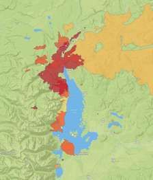
This is the specific site referenced as "A Patchwork of Habitats." The overlook provides a textbook view of ecological succession and fire history. From the vantage point, you can see how repeated fires have created a mosaic of forest ages across the landscape, which is crucial for biodiversity. The park's Fire History page details the burns you're looking at, including the ones discussed by Diane and Ron in the park's interpretive materials. It's a thinking person's viewpoint.
Blacktail Ponds Overlook
Another stop that emphasizes the park's ecological variety. From here, the ponds and wet meadows along the Snake River demonstrate the wetland community. It's a prime area for birding. Look for trumpeter swans, sandhill cranes, and a variety of waterfowl. The overlook is just a pull-off on the main highway, an easy stop to stretch your legs and scan for wildlife.

Activities
The park's verified list of over 50 activities centers on hiking, water, and wildlife. For detailed route descriptions and current trail conditions, consult our dedicated guide to the park's hiking trails.
Hiking ranges from the paved, 0.25-mile Lunch Tree Hill path at Jackson Lake Lodge to the brutal 20-mile Paintbrush Canyon-Cascade Canyon Loop. The mid-range classics are where most visitors find their stride: the 3.2-mile round trip to Taggart Lake, the 6.6-mile Jenny Lake Loop, and the 4.9-mile round trip to Inspiration Point via the boat shuttle. The trail narrows on many of these routes, with roots and rocks underfoot.
Wildlife viewing is not a passive activity here. It requires timing (dawn and dusk) and knowing where to look. The wet meadows along the Moose-Wilson Road are moose magnets. The sagebrush flats near Mormon Row and Antelope Flats are where you'll find pronghorn and bison. For a focused deep dive, our wildlife viewing guide has specific locations and tips.
Water activities define a Teton summer. You can rent kayaks, canoes, and paddleboards at Colter Bay, Signal Mountain, and Jenny Lake. The water is cold year-round - a sudden capsize is a serious hypothermia risk. Scenic float trips on the Snake River are a peaceful way to see the park from a different angle; multiple concessioners offer guided trips.
For those who prefer a structured experience, the park and its partners offer a range of tours and guided experiences, from photography workshops to naturalist-led hikes.
Seasonal Guide
The park transforms completely with the seasons. Your experience in February will have almost nothing in common with one in August.
Winter (December - March): Cold and quiet. Teton Park Road is closed to vehicles from Taggart Lake to Signal Mountain, becoming a trail for cross-country skiing and snowshoeing. The Moose-Wilson Road is also closed, making it a serene corridor for winter recreation. Temperatures routinely drop below zero. The park's lodging and accommodations are limited to a few open facilities.
Spring (April - June): Unpredictable. Snow lingers at high elevations well into July. Valley trails like those around Phelps Lake may be clear and muddy by May, while higher routes remain snowbound. This is the season for runoff - rivers are high, fast, and dangerous. Wildflowers begin in the valley in June. Crowds are lighter until late June.
Summer (July - September): The main season. All roads and facilities are open. Daytime temperatures in the valley are pleasant (70s-80s°F), but nights are cool. Afternoon thunderstorms are frequent. This is the only reliable window for high-elevation hikes like the Static Peak Divide Trail or the Paintbrush-Cascade Loop. Crowds peak in late July and August. For a detailed breakdown of weather patterns, see our guide on the best time to visit.
Fall (October - November): A crisp, golden interlude. The first snows dust the high peaks in September. By October, the aspen and cottonwoods in the valley are brilliant yellow. Cold nights return. Facilities begin to close after October 1st. Crowds thin dramatically, making it a favorite for photographers and those seeking solitude, though weather windows can be short.

Practical Information
As of 2026, standard entrance fees apply: $35/vehicle, $30/motorcycle, $20/person (foot, bike). The annual park pass is $70. The America the Beautiful Interagency Pass ($80) is the best value if you visit more than two national parks in a year.
For camping options, the park has six major campgrounds with over 900 combined sites. Reservations are essential. Jenny Lake Campground (61 sites, $56) is first-come, first-served and fills before 8 AM daily in summer. The others - Colter Bay (324 sites, $59), Gros Ventre (279 sites, $57), Signal Mountain (81 sites, $55), and Lizard Creek (60 sites, $49) - are reservable up to six months in advance on Recreation.gov. Colter Bay also has an RV Park with full hookups for $117.
Backcountry camping requires a permit, available by reservation or in-person the day before your trip. Bear canisters are mandatory for all food and scented items.
Lodging inside the park includes historic lodges like Jackson Lake Lodge and Jenny Lake Lodge, plus cabins at Colter Bay. These book up a year in advance for summer. The town of Jackson, 12 miles south, offers a full range of hotels and services. Gas is available at Colter Bay, Signal Mountain, and in Jackson; fill up before exploring.
Safety & Preparation
Altitude is your first consideration. The valley floor is at 6,800 feet. Drink twice as much water as you think you need. Headaches and fatigue are common first-day symptoms.
This is serious bear country - both black and grizzly bears. Carry bear spray on your hip, not in your pack. Know how to use it. Make noise on the trail, especially in brushy areas or when approaching blind corners. Hike in groups of three or more.
Weather changes fast. A sunny morning can become a lightning storm by afternoon. Get an early start to be off high, exposed ridges by noon. The water in lakes and rivers is snowmelt and dangerously cold, even in August. A life jacket is non-negotiable for any boating.
Tell someone your plans. Cell service drops out at most trailheads. Emergency services are based at Moose. In an emergency, dial 911 or contact a park ranger.

Insider Tips
- The Jenny Lake Shuttle Alternative: The line for the boat shuttle can be an hour long by 10 AM. The hike along the south shore of the lake to the Cascade Canyon trailhead is 2.4 miles of flat, pleasant trail. Many find it faster to walk than to wait.
- Second Sunrise: Everyone heads to Oxbow Bend at dawn. For a different classic shot with fewer people, the Mormon Row barns are spectacular in the first light, which hits them slightly later than the river.
- Moose-Wilson Road Timing: This road is narrow, winding, and often lined with parked cars from wildlife watchers. Drive it very early in the morning or in the evening, not in the middle of the day when it becomes a traffic jam.
- Parking Protocol: If a trailhead lot is full, do not park on vegetation or block roads. Rangers ticket aggressively. Use the overflow parking at the Jenny Lake area and take the park's internal shuttle, or have a backup plan ready.
- The Colter Bay Advantage: With parkwide construction planned for 2026, Colter Bay is anticipated to be less affected. Its large campground, visitor center, marina, and restaurant make it a self-contained and potentially more reliable base.
- Check the Trail Register: At the start of most major trails, there's a clipboard for hikers to sign in. Glance at the comments from earlier in the day. You'll find real-time, unfiltered info on trail conditions, wildlife sightings, and bug reports.
- The Gift Shop Sells Bear Spray: You can rent or buy bear spray at every visitor center and most general stores in the park. If you flew in, this is the easiest solution. Renting for a few days is often more economical than buying.
For more information, see our complete Grand Teton National Park Guide.
Sources
- Official source: NPS — Grand Teton National Park nps.gov/grte/index.htm
- Official source: National Park Service nps.gov/places/000/a-patchwork-of-habitats.htm
Photo Gallery
More to Explore

Park Guide
Acadia National Park: Carriage Roads, Cadillac Mountain & 2026 Guide
Discover carriage roads, Cadillac Mountain, and rugged Maine coast. Complete 2026 guide to Acadia National Park — trails, fees, lodging, permits, and what rangers recommend.

Hiking Guide
Grand Canyon Hiking Trails: Day Hikes, Water Sources & Rim to Rim
Compare Grand Canyon hiking trails: Bright Angel, South Kaibab, Hermit, Grandview, and rim to rim, with distances, elevation, water stops, and trailhead access for each.

Best Of
Best of Glacier Bay National Park
The best of Glacier Bay is reached by boat: ranger-led day tours up the bay to the tidewater glaciers. What's worth it, how to book, and when to go (2026).

Campsite Guide
White Sands Backcountry Camping: Closed for 2026 — What to Know
As of 2026, backcountry camping at White Sands National Park is closed for site rehabilitation. What that means, and where to camp nearby instead.

Weather Guide
Guadalupe Mountains National Park Weather: Weather
Guadalupe Mountains National Park: weather guide guide updated 2026. Practical visitor information, reservations, and seasonal tips worth bookmarking before

Best Of
Best of Cuyahoga Valley National Park: Best Things to Do
Seeing a Cleveland Orchestra concert with the woods as your backdrop is a uniquely Cuyahoga Valley experience.
Sign in to join the conversation.
Sources & Attribution
Location data courtesy of the National Park Service (U.S. Department of the Interior). NPS data is public domain. Official NPS page.
Images: NPS; NPS; NPS; NPS; NPS.
Map data © OpenStreetMap contributors.
Park operations alerts: NPS.gov · Weather and weather hazards: National Weather Service · Live conditions.
Information may change. Always verify fees, hours, and conditions directly with the official source before visiting.
Did this guide help? Share it with a friend.